You are here: Home > Network List > AV - Alaska Volcano Observatory Stations List
> Station TASO South, Tanaga Volcano, Alaska > Earthquake Result Viewer
TASO South, Tanaga Volcano, Alaska - Earthquake Result Viewer
| Earthquake location: |
Minahassa Peninsula, Sulawesi |
| Earthquake latitude/longitude: |
0.1/123.7 |
| Earthquake time(UTC): |
2022/06/07 (158) 13:24:13 GMT |
| Earthquake Depth: |
132 km |
| Earthquake Magnitude: |
5.6 mww |
| Earthquake Catalog/Contributor: |
NEIC PDE/us |
|
| Network: |
AV Alaska Volcano Observatory |
| Station: |
TASO South, Tanaga Volcano, Alaska |
| Lat/Lon: |
51.85 N/178.15 W |
| Elevation: |
690 m |
|
| Distance: |
70.8 deg |
| Az: |
33.928 deg |
| Baz: |
244.143 deg |
| Ray Param: |
0.054414675 |
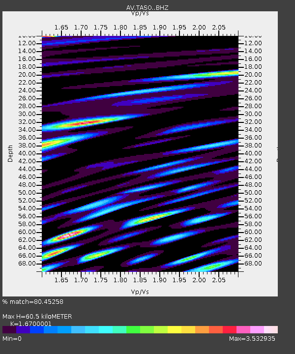
| Estimated Moho Depth: |
60.5 km |
| Estimated Crust Vp/Vs: |
1.67 |
| Assumed Crust Vp: |
6.048 km/s |
| Estimated Crust Vs: |
3.622 km/s |
| Estimated Crust Poisson's Ratio: |
0.22 |
|
| Radial Match: |
80.45258 % |
| Radial Bump: |
400 |
| Transverse Match: |
79.84618 % |
| Transverse Bump: |
400 |
| SOD ConfigId: |
28208852 |
| Insert Time: |
2022-06-27 16:52:38.672 +0000 |
| GWidth: |
2.5 |
| Max Bumps: |
400 |
| Tol: |
0.001 |
|

Signal To Noise
| Channel | StoN | STA | LTA |
| AV:TASO: :BHZ:20220607T13:34:45.258973Z | 12.763588 | 1.1672594E-6 | 9.1452286E-8 |
| AV:TASO: :BHN:20220607T13:34:45.258973Z | 5.0060134 | 1.3685046E-6 | 2.7337214E-7 |
| AV:TASO: :BHE:20220607T13:34:45.258973Z | 2.384962 | 7.675695E-7 | 3.2183718E-7 |
| Arrivals |
| Ps | 6.9 SECOND |
| PpPs | 26 SECOND |
| PsPs/PpSs | 33 SECOND |


