You are here: Home > Network List > TX - Texas Seismological Network Stations List
> Station SN05 Snyder 5 > Earthquake Result Viewer
SN05 Snyder 5 - Earthquake Result Viewer
| Earthquake location: |
Northern Alaska |
| Earthquake latitude/longitude: |
69.6/-145.3 |
| Earthquake time(UTC): |
2018/08/12 (224) 14:58:54 GMT |
| Earthquake Depth: |
2.2 km |
| Earthquake Magnitude: |
6.3 ml |
| Earthquake Catalog/Contributor: |
NEIC PDE/ak |
|
| Network: |
TX Texas Seismological Network |
| Station: |
SN05 Snyder 5 |
| Lat/Lon: |
32.88 N/100.88 W |
| Elevation: |
724 m |
|
| Distance: |
44.2 deg |
| Az: |
122.347 deg |
| Baz: |
339.35 deg |
| Ray Param: |
0.07208673 |
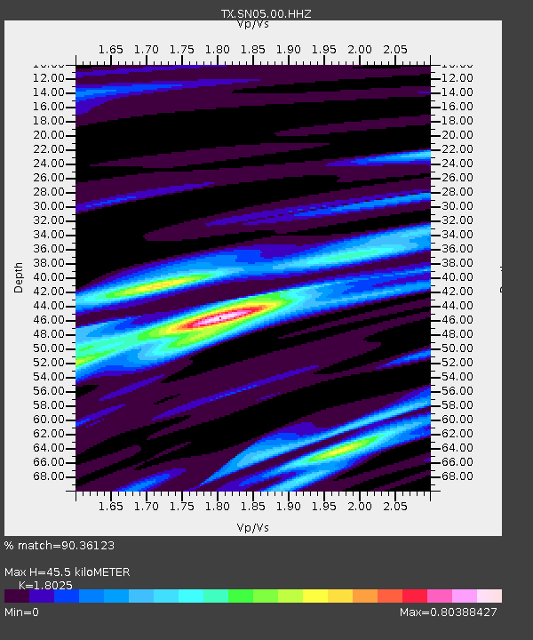
| Estimated Moho Depth: |
45.5 km |
| Estimated Crust Vp/Vs: |
1.80 |
| Assumed Crust Vp: |
6.426 km/s |
| Estimated Crust Vs: |
3.565 km/s |
| Estimated Crust Poisson's Ratio: |
0.28 |
|
| Radial Match: |
90.36123 % |
| Radial Bump: |
330 |
| Transverse Match: |
60.765656 % |
| Transverse Bump: |
400 |
| SOD ConfigId: |
2825771 |
| Insert Time: |
2018-08-26 15:07:04.270 +0000 |
| GWidth: |
2.5 |
| Max Bumps: |
400 |
| Tol: |
0.001 |
|

Signal To Noise
| Channel | StoN | STA | LTA |
| TX:SN05:00:HHZ:20180812T15:06:33.634999Z | 7.650073 | 5.490975E-7 | 7.177676E-8 |
| TX:SN05:00:HH1:20180812T15:06:33.634999Z | 3.1336107 | 2.1666298E-7 | 6.914164E-8 |
| TX:SN05:00:HH2:20180812T15:06:33.634999Z | 1.7329358 | 1.2621966E-7 | 7.283574E-8 |
| Arrivals |
| Ps | 6.1 SECOND |
| PpPs | 19 SECOND |
| PsPs/PpSs | 25 SECOND |


