You are here: Home > Network List > AE - Arizona Broadband Seismic Network Stations List
> Station W18A Petrified Forest, AZ, USA > Earthquake Result Viewer
W18A Petrified Forest, AZ, USA - Earthquake Result Viewer
| Earthquake location: |
Peru-Brazil Border Region |
| Earthquake latitude/longitude: |
-9.0/-71.2 |
| Earthquake time(UTC): |
2022/06/08 (159) 00:55:47 GMT |
| Earthquake Depth: |
622 km |
| Earthquake Magnitude: |
6.5 Mww |
| Earthquake Catalog/Contributor: |
NEIC PDE/us |
|
| Network: |
AE Arizona Broadband Seismic Network |
| Station: |
W18A Petrified Forest, AZ, USA |
| Lat/Lon: |
35.12 N/109.74 W |
| Elevation: |
1750 m |
|
| Distance: |
57.1 deg |
| Az: |
322.5 deg |
| Baz: |
132.821 deg |
| Ray Param: |
0.06108761 |
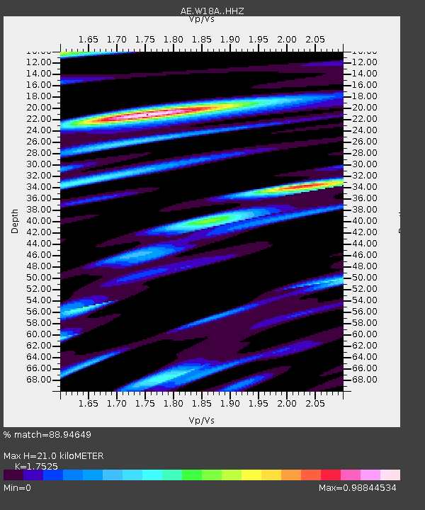
| Estimated Moho Depth: |
21.0 km |
| Estimated Crust Vp/Vs: |
1.75 |
| Assumed Crust Vp: |
6.496 km/s |
| Estimated Crust Vs: |
3.707 km/s |
| Estimated Crust Poisson's Ratio: |
0.26 |
|
| Radial Match: |
88.94649 % |
| Radial Bump: |
344 |
| Transverse Match: |
60.202503 % |
| Transverse Bump: |
400 |
| SOD ConfigId: |
28208852 |
| Insert Time: |
2022-06-27 16:59:41.455 +0000 |
| GWidth: |
2.5 |
| Max Bumps: |
400 |
| Tol: |
0.001 |
|

Signal To Noise
| Channel | StoN | STA | LTA |
| AE:W18A: :HHZ:20220608T01:04:05.208985Z | 30.162312 | 2.0694765E-6 | 6.861134E-8 |
| AE:W18A: :HHN:20220608T01:04:05.208985Z | 11.954167 | 9.261431E-7 | 7.7474496E-8 |
| AE:W18A: :HHE:20220608T01:04:05.208985Z | 11.430624 | 1.0638303E-6 | 9.306843E-8 |
| Arrivals |
| Ps | 2.6 SECOND |
| PpPs | 8.5 SECOND |
| PsPs/PpSs | 11 SECOND |


