You are here: Home > Network List > AG - Arkansas Seismic Network Stations List
> Station HHAR Hobbs,AR > Earthquake Result Viewer
HHAR Hobbs,AR - Earthquake Result Viewer
| Earthquake location: |
Peru-Brazil Border Region |
| Earthquake latitude/longitude: |
-9.0/-71.2 |
| Earthquake time(UTC): |
2022/06/08 (159) 00:55:47 GMT |
| Earthquake Depth: |
622 km |
| Earthquake Magnitude: |
6.5 Mww |
| Earthquake Catalog/Contributor: |
NEIC PDE/us |
|
| Network: |
AG Arkansas Seismic Network |
| Station: |
HHAR Hobbs,AR |
| Lat/Lon: |
36.28 N/93.94 W |
| Elevation: |
421 m |
|
| Distance: |
49.9 deg |
| Az: |
335.89 deg |
| Baz: |
150.043 deg |
| Ray Param: |
0.065447606 |
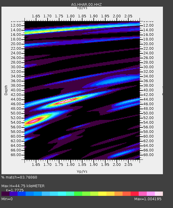
| Estimated Moho Depth: |
44.75 km |
| Estimated Crust Vp/Vs: |
1.77 |
| Assumed Crust Vp: |
6.53 km/s |
| Estimated Crust Vs: |
3.684 km/s |
| Estimated Crust Poisson's Ratio: |
0.27 |
|
| Radial Match: |
83.76868 % |
| Radial Bump: |
348 |
| Transverse Match: |
67.35959 % |
| Transverse Bump: |
383 |
| SOD ConfigId: |
28208852 |
| Insert Time: |
2022-06-27 16:59:54.259 +0000 |
| GWidth: |
2.5 |
| Max Bumps: |
400 |
| Tol: |
0.001 |
|

Signal To Noise
| Channel | StoN | STA | LTA |
| AG:HHAR:00:HHZ:20220608T01:03:15.109986Z | 29.975147 | 3.9859E-6 | 1.3297348E-7 |
| AG:HHAR:00:HHN:20220608T01:03:15.109986Z | 11.312072 | 1.3034502E-6 | 1.1522647E-7 |
| AG:HHAR:00:HHE:20220608T01:03:15.109986Z | 12.849286 | 1.1781655E-6 | 9.169113E-8 |
| Arrivals |
| Ps | 5.6 SECOND |
| PpPs | 18 SECOND |
| PsPs/PpSs | 24 SECOND |


