You are here: Home > Network List > US - United States National Seismic Network Stations List
> Station COWI Conover, Wisconsin, USA > Earthquake Result Viewer
COWI Conover, Wisconsin, USA - Earthquake Result Viewer
| Earthquake location: |
Northern Alaska |
| Earthquake latitude/longitude: |
69.6/-145.3 |
| Earthquake time(UTC): |
2018/08/12 (224) 14:58:54 GMT |
| Earthquake Depth: |
2.2 km |
| Earthquake Magnitude: |
6.3 ml |
| Earthquake Catalog/Contributor: |
NEIC PDE/ak |
|
| Network: |
US United States National Seismic Network |
| Station: |
COWI Conover, Wisconsin, USA |
| Lat/Lon: |
46.10 N/89.14 W |
| Elevation: |
523 m |
|
| Distance: |
36.0 deg |
| Az: |
100.822 deg |
| Baz: |
330.275 deg |
| Ray Param: |
0.07691369 |
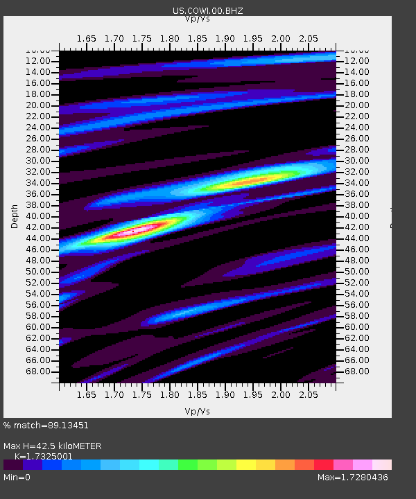
| Estimated Moho Depth: |
42.5 km |
| Estimated Crust Vp/Vs: |
1.73 |
| Assumed Crust Vp: |
6.467 km/s |
| Estimated Crust Vs: |
3.733 km/s |
| Estimated Crust Poisson's Ratio: |
0.25 |
|
| Radial Match: |
89.13451 % |
| Radial Bump: |
320 |
| Transverse Match: |
67.18906 % |
| Transverse Bump: |
400 |
| SOD ConfigId: |
2825771 |
| Insert Time: |
2018-08-26 15:07:53.798 +0000 |
| GWidth: |
2.5 |
| Max Bumps: |
400 |
| Tol: |
0.001 |
|

Signal To Noise
| Channel | StoN | STA | LTA |
| US:COWI:00:BHZ:20180812T15:05:26.150014Z | 12.983304 | 1.3034016E-6 | 1.003906E-7 |
| US:COWI:00:BH1:20180812T15:05:26.150014Z | 8.980456 | 7.4956876E-7 | 8.346667E-8 |
| US:COWI:00:BH2:20180812T15:05:26.150014Z | 6.993654 | 5.050931E-7 | 7.222163E-8 |
| Arrivals |
| Ps | 5.2 SECOND |
| PpPs | 17 SECOND |
| PsPs/PpSs | 22 SECOND |


