You are here: Home > Network List > CI - Caltech Regional Seismic Network Stations List
> Station SWS Sam W. Stewart, Westmorland, CA, USA > Earthquake Result Viewer
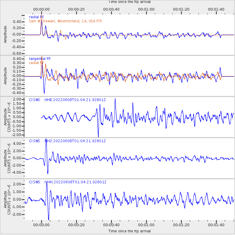
SWS Sam W. Stewart, Westmorland, CA, USA - Earthquake Result Viewer
*The percent match for this event was below the threshold and hence no stack was calculated.
| Earthquake location: |
Peru-Brazil Border Region |
| Earthquake latitude/longitude: |
-9.0/-71.2 |
| Earthquake time(UTC): |
2022/06/08 (159) 00:55:47 GMT |
| Earthquake Depth: |
622 km |
| Earthquake Magnitude: |
6.5 Mww |
| Earthquake Catalog/Contributor: |
NEIC PDE/us |
|
| Network: |
CI Caltech Regional Seismic Network |
| Station: |
SWS Sam W. Stewart, Westmorland, CA, USA |
| Lat/Lon: |
32.94 N/115.80 W |
| Elevation: |
140 m |
|
| Distance: |
59.6 deg |
| Az: |
316.764 deg |
| Baz: |
126.427 deg |
| Ray Param: |
$rayparam |
*The percent match for this event was below the threshold and hence was not used in the summary stack. |
|
| Radial Match: |
75.9576 % |
| Radial Bump: |
400 |
| Transverse Match: |
75.14986 % |
| Transverse Bump: |
355 |
| SOD ConfigId: |
28208852 |
| Insert Time: |
2022-06-27 17:10:36.163 +0000 |
| GWidth: |
2.5 |
| Max Bumps: |
400 |
| Tol: |
0.001 |
|
Signal To Noise
| Channel | StoN | STA | LTA |
| CI:SWS: :HHZ:20220608T01:04:21.92801Z | 15.910214 | 2.1984083E-6 | 1.3817589E-7 |
| CI:SWS: :HHN:20220608T01:04:21.92801Z | 3.6240373 | 1.0825024E-6 | 2.9870068E-7 |
| CI:SWS: :HHE:20220608T01:04:21.92801Z | 3.2002 | 7.915021E-7 | 2.4732896E-7 |
| Arrivals |
| Ps | |
| PpPs | |
| PsPs/PpSs | |


