You are here: Home > Network List > GM - US Geological Survey Networks Stations List
> Station NMP11 New Mexico Permian - Site# W1S1 > Earthquake Result Viewer
NMP11 New Mexico Permian - Site# W1S1 - Earthquake Result Viewer
| Earthquake location: |
Peru-Brazil Border Region |
| Earthquake latitude/longitude: |
-9.0/-71.2 |
| Earthquake time(UTC): |
2022/06/08 (159) 00:55:47 GMT |
| Earthquake Depth: |
622 km |
| Earthquake Magnitude: |
6.5 Mww |
| Earthquake Catalog/Contributor: |
NEIC PDE/us |
|
| Network: |
GM US Geological Survey Networks |
| Station: |
NMP11 New Mexico Permian - Site# W1S1 |
| Lat/Lon: |
32.01 N/103.93 W |
| Elevation: |
883 m |
|
| Distance: |
51.4 deg |
| Az: |
324.004 deg |
| Baz: |
136.898 deg |
| Ray Param: |
0.06452374 |
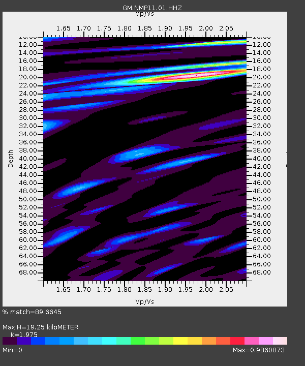
| Estimated Moho Depth: |
19.25 km |
| Estimated Crust Vp/Vs: |
1.98 |
| Assumed Crust Vp: |
6.129 km/s |
| Estimated Crust Vs: |
3.103 km/s |
| Estimated Crust Poisson's Ratio: |
0.33 |
|
| Radial Match: |
89.6645 % |
| Radial Bump: |
400 |
| Transverse Match: |
63.20336 % |
| Transverse Bump: |
400 |
| SOD ConfigId: |
28208852 |
| Insert Time: |
2022-06-27 17:16:28.935 +0000 |
| GWidth: |
2.5 |
| Max Bumps: |
400 |
| Tol: |
0.001 |
|

Signal To Noise
| Channel | StoN | STA | LTA |
| GM:NMP11:01:HHZ:20220608T01:03:26.070008Z | 33.493793 | 5.2271557E-6 | 1.560634E-7 |
| GM:NMP11:01:HHN:20220608T01:03:26.070008Z | 12.215626 | 1.343649E-6 | 1.0999429E-7 |
| GM:NMP11:01:HHE:20220608T01:03:26.070008Z | 16.398767 | 1.9605752E-6 | 1.1955625E-7 |
| Arrivals |
| Ps | 3.2 SECOND |
| PpPs | 9.0 SECOND |
| PsPs/PpSs | 12 SECOND |


