You are here: Home > Network List > GM - US Geological Survey Networks Stations List
> Station NMP12 New Mexico Permian - Site# W1S2 > Earthquake Result Viewer
NMP12 New Mexico Permian - Site# W1S2 - Earthquake Result Viewer
| Earthquake location: |
Peru-Brazil Border Region |
| Earthquake latitude/longitude: |
-9.0/-71.2 |
| Earthquake time(UTC): |
2022/06/08 (159) 00:55:47 GMT |
| Earthquake Depth: |
622 km |
| Earthquake Magnitude: |
6.5 Mww |
| Earthquake Catalog/Contributor: |
NEIC PDE/us |
|
| Network: |
GM US Geological Survey Networks |
| Station: |
NMP12 New Mexico Permian - Site# W1S2 |
| Lat/Lon: |
32.13 N/103.95 W |
| Elevation: |
952 m |
|
| Distance: |
51.5 deg |
| Az: |
324.092 deg |
| Baz: |
136.942 deg |
| Ray Param: |
0.0644637 |
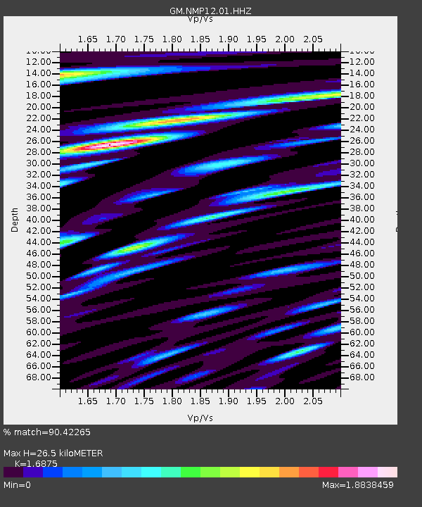
| Estimated Moho Depth: |
26.5 km |
| Estimated Crust Vp/Vs: |
1.69 |
| Assumed Crust Vp: |
6.129 km/s |
| Estimated Crust Vs: |
3.632 km/s |
| Estimated Crust Poisson's Ratio: |
0.23 |
|
| Radial Match: |
90.42265 % |
| Radial Bump: |
400 |
| Transverse Match: |
81.33748 % |
| Transverse Bump: |
400 |
| SOD ConfigId: |
28208852 |
| Insert Time: |
2022-06-27 17:16:30.851 +0000 |
| GWidth: |
2.5 |
| Max Bumps: |
400 |
| Tol: |
0.001 |
|

Signal To Noise
| Channel | StoN | STA | LTA |
| GM:NMP12:01:HHZ:20220608T01:03:26.790009Z | 29.475285 | 7.093137E-6 | 2.4064693E-7 |
| GM:NMP12:01:HHN:20220608T01:03:26.790009Z | 12.155107 | 2.1544563E-6 | 1.7724702E-7 |
| GM:NMP12:01:HHE:20220608T01:03:26.790009Z | 23.08674 | 4.189901E-6 | 1.8148518E-7 |
| Arrivals |
| Ps | 3.1 SECOND |
| PpPs | 11 SECOND |
| PsPs/PpSs | 14 SECOND |


