You are here: Home > Network List > GM - US Geological Survey Networks Stations List
> Station NMP34 New Mexico Permian - Site# W3S4 > Earthquake Result Viewer
NMP34 New Mexico Permian - Site# W3S4 - Earthquake Result Viewer
| Earthquake location: |
Peru-Brazil Border Region |
| Earthquake latitude/longitude: |
-9.0/-71.2 |
| Earthquake time(UTC): |
2022/06/08 (159) 00:55:47 GMT |
| Earthquake Depth: |
622 km |
| Earthquake Magnitude: |
6.5 Mww |
| Earthquake Catalog/Contributor: |
NEIC PDE/us |
|
| Network: |
GM US Geological Survey Networks |
| Station: |
NMP34 New Mexico Permian - Site# W3S4 |
| Lat/Lon: |
32.26 N/103.69 W |
| Elevation: |
1122 m |
|
| Distance: |
51.5 deg |
| Az: |
324.419 deg |
| Baz: |
137.285 deg |
| Ray Param: |
0.064495064 |
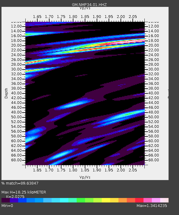
| Estimated Moho Depth: |
18.25 km |
| Estimated Crust Vp/Vs: |
2.03 |
| Assumed Crust Vp: |
6.129 km/s |
| Estimated Crust Vs: |
3.023 km/s |
| Estimated Crust Poisson's Ratio: |
0.34 |
|
| Radial Match: |
89.63847 % |
| Radial Bump: |
400 |
| Transverse Match: |
68.82644 % |
| Transverse Bump: |
400 |
| SOD ConfigId: |
28208852 |
| Insert Time: |
2022-06-27 17:16:35.706 +0000 |
| GWidth: |
2.5 |
| Max Bumps: |
400 |
| Tol: |
0.001 |
|

Signal To Noise
| Channel | StoN | STA | LTA |
| GM:NMP34:01:HHZ:20220608T01:03:26.415009Z | 22.27926 | 4.475145E-6 | 2.0086595E-7 |
| GM:NMP34:01:HHN:20220608T01:03:26.415009Z | 9.340107 | 1.3306666E-6 | 1.4246804E-7 |
| GM:NMP34:01:HHE:20220608T01:03:26.415009Z | 12.024759 | 1.5090535E-6 | 1.2549553E-7 |
| Arrivals |
| Ps | 3.2 SECOND |
| PpPs | 8.7 SECOND |
| PsPs/PpSs | 12 SECOND |


