You are here: Home > Network List > GM - US Geological Survey Networks Stations List
> Station NMP35 New Mexico Permian - Site# W3S5 > Earthquake Result Viewer
NMP35 New Mexico Permian - Site# W3S5 - Earthquake Result Viewer
| Earthquake location: |
Peru-Brazil Border Region |
| Earthquake latitude/longitude: |
-9.0/-71.2 |
| Earthquake time(UTC): |
2022/06/08 (159) 00:55:47 GMT |
| Earthquake Depth: |
622 km |
| Earthquake Magnitude: |
6.5 Mww |
| Earthquake Catalog/Contributor: |
NEIC PDE/us |
|
| Network: |
GM US Geological Survey Networks |
| Station: |
NMP35 New Mexico Permian - Site# W3S5 |
| Lat/Lon: |
32.35 N/103.72 W |
| Elevation: |
1071 m |
|
| Distance: |
51.6 deg |
| Az: |
324.467 deg |
| Baz: |
137.296 deg |
| Ray Param: |
0.064443834 |
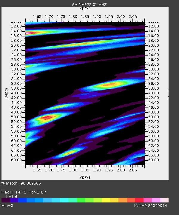
| Estimated Moho Depth: |
14.75 km |
| Estimated Crust Vp/Vs: |
1.60 |
| Assumed Crust Vp: |
6.129 km/s |
| Estimated Crust Vs: |
3.831 km/s |
| Estimated Crust Poisson's Ratio: |
0.18 |
|
| Radial Match: |
90.389565 % |
| Radial Bump: |
400 |
| Transverse Match: |
55.21878 % |
| Transverse Bump: |
400 |
| SOD ConfigId: |
28208852 |
| Insert Time: |
2022-06-27 17:16:37.407 +0000 |
| GWidth: |
2.5 |
| Max Bumps: |
400 |
| Tol: |
0.001 |
|

Signal To Noise
| Channel | StoN | STA | LTA |
| GM:NMP35:01:HHZ:20220608T01:03:27.01999Z | 21.908077 | 3.9578968E-6 | 1.8065924E-7 |
| GM:NMP35:01:HHN:20220608T01:03:27.01999Z | 9.887529 | 1.0110009E-6 | 1.022501E-7 |
| GM:NMP35:01:HHE:20220608T01:03:27.01999Z | 17.553242 | 1.127344E-6 | 6.422426E-8 |
| Arrivals |
| Ps | 1.5 SECOND |
| PpPs | 5.9 SECOND |
| PsPs/PpSs | 7.5 SECOND |


