You are here: Home > Network List > GS - US Geological Survey Networks Stations List
> Station MCA04 MCA04, Monte Cristo Range, NV > Earthquake Result Viewer
MCA04 MCA04, Monte Cristo Range, NV - Earthquake Result Viewer
| Earthquake location: |
Peru-Brazil Border Region |
| Earthquake latitude/longitude: |
-9.0/-71.2 |
| Earthquake time(UTC): |
2022/06/08 (159) 00:55:47 GMT |
| Earthquake Depth: |
622 km |
| Earthquake Magnitude: |
6.5 Mww |
| Earthquake Catalog/Contributor: |
NEIC PDE/us |
|
| Network: |
GS US Geological Survey Networks |
| Station: |
MCA04 MCA04, Monte Cristo Range, NV |
| Lat/Lon: |
38.08 N/117.71 W |
| Elevation: |
1662 m |
|
| Distance: |
63.9 deg |
| Az: |
320.367 deg |
| Baz: |
127.029 deg |
| Ray Param: |
0.056909975 |
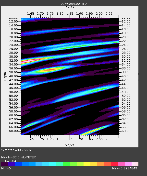
| Estimated Moho Depth: |
32.0 km |
| Estimated Crust Vp/Vs: |
1.64 |
| Assumed Crust Vp: |
6.276 km/s |
| Estimated Crust Vs: |
3.827 km/s |
| Estimated Crust Poisson's Ratio: |
0.20 |
|
| Radial Match: |
80.75687 % |
| Radial Bump: |
400 |
| Transverse Match: |
80.20318 % |
| Transverse Bump: |
400 |
| SOD ConfigId: |
28208852 |
| Insert Time: |
2022-06-27 17:17:15.190 +0000 |
| GWidth: |
2.5 |
| Max Bumps: |
400 |
| Tol: |
0.001 |
|

Signal To Noise
| Channel | StoN | STA | LTA |
| GS:MCA04:00:HHZ:20220608T01:04:49.745026Z | 39.377186 | 3.171811E-6 | 8.0549455E-8 |
| GS:MCA04:00:HH1:20220608T01:04:49.745026Z | 10.391361 | 7.337444E-7 | 7.0611E-8 |
| GS:MCA04:00:HH2:20220608T01:04:49.745026Z | 8.396049 | 8.138249E-7 | 9.692952E-8 |
| Arrivals |
| Ps | 3.4 SECOND |
| PpPs | 13 SECOND |
| PsPs/PpSs | 16 SECOND |


