You are here: Home > Network List > N4 - Central and EAstern US Network Stations List
> Station F42A Maple Grove Farm, Niagara, WI, USA > Earthquake Result Viewer
F42A Maple Grove Farm, Niagara, WI, USA - Earthquake Result Viewer
| Earthquake location: |
Peru-Brazil Border Region |
| Earthquake latitude/longitude: |
-9.0/-71.2 |
| Earthquake time(UTC): |
2022/06/08 (159) 00:55:47 GMT |
| Earthquake Depth: |
622 km |
| Earthquake Magnitude: |
6.5 Mww |
| Earthquake Catalog/Contributor: |
NEIC PDE/us |
|
| Network: |
N4 Central and EAstern US Network |
| Station: |
F42A Maple Grove Farm, Niagara, WI, USA |
| Lat/Lon: |
45.76 N/88.13 W |
| Elevation: |
358 m |
|
| Distance: |
56.6 deg |
| Az: |
345.856 deg |
| Baz: |
159.833 deg |
| Ray Param: |
0.061352707 |
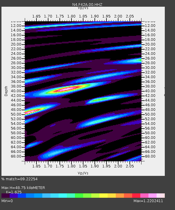
| Estimated Moho Depth: |
48.75 km |
| Estimated Crust Vp/Vs: |
1.62 |
| Assumed Crust Vp: |
6.41 km/s |
| Estimated Crust Vs: |
3.945 km/s |
| Estimated Crust Poisson's Ratio: |
0.20 |
|
| Radial Match: |
89.22254 % |
| Radial Bump: |
400 |
| Transverse Match: |
72.15419 % |
| Transverse Bump: |
400 |
| SOD ConfigId: |
28208852 |
| Insert Time: |
2022-06-27 17:20:57.185 +0000 |
| GWidth: |
2.5 |
| Max Bumps: |
400 |
| Tol: |
0.001 |
|

Signal To Noise
| Channel | StoN | STA | LTA |
| N4:F42A:00:HHZ:20220608T01:04:02.368989Z | 22.36984 | 3.217843E-6 | 1.4384739E-7 |
| N4:F42A:00:HH1:20220608T01:04:02.368989Z | 19.133701 | 2.6006485E-6 | 1.3591978E-7 |
| N4:F42A:00:HH2:20220608T01:04:02.368989Z | 13.673361 | 1.8244124E-6 | 1.3342824E-7 |
| Arrivals |
| Ps | 5.0 SECOND |
| PpPs | 19 SECOND |
| PsPs/PpSs | 24 SECOND |


