You are here: Home > Network List > O2 - Oklahoma Consolidated Temporary Seismic Networks Stations List
> Station DRIP Dripping spring state park, Oklahoma, USA > Earthquake Result Viewer
DRIP Dripping spring state park, Oklahoma, USA - Earthquake Result Viewer
| Earthquake location: |
Peru-Brazil Border Region |
| Earthquake latitude/longitude: |
-9.0/-71.2 |
| Earthquake time(UTC): |
2022/06/08 (159) 00:55:47 GMT |
| Earthquake Depth: |
622 km |
| Earthquake Magnitude: |
6.5 Mww |
| Earthquake Catalog/Contributor: |
NEIC PDE/us |
|
| Network: |
O2 Oklahoma Consolidated Temporary Seismic Networks |
| Station: |
DRIP Dripping spring state park, Oklahoma, USA |
| Lat/Lon: |
35.61 N/96.07 W |
| Elevation: |
243 m |
|
| Distance: |
50.2 deg |
| Az: |
333.517 deg |
| Baz: |
147.278 deg |
| Ray Param: |
0.065249145 |
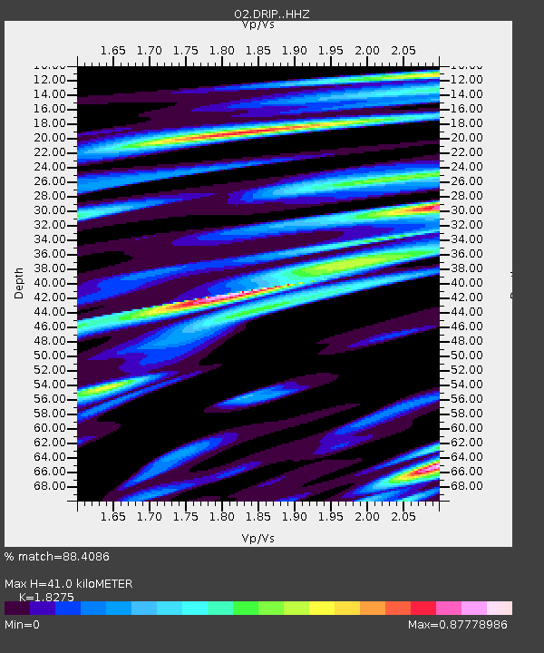
| Estimated Moho Depth: |
41.0 km |
| Estimated Crust Vp/Vs: |
1.83 |
| Assumed Crust Vp: |
6.426 km/s |
| Estimated Crust Vs: |
3.516 km/s |
| Estimated Crust Poisson's Ratio: |
0.29 |
|
| Radial Match: |
88.4086 % |
| Radial Bump: |
400 |
| Transverse Match: |
59.83942 % |
| Transverse Bump: |
400 |
| SOD ConfigId: |
28208852 |
| Insert Time: |
2022-06-27 17:25:30.953 +0000 |
| GWidth: |
2.5 |
| Max Bumps: |
400 |
| Tol: |
0.001 |
|

Signal To Noise
| Channel | StoN | STA | LTA |
| O2:DRIP: :HHZ:20220608T01:03:17.480012Z | 65.078735 | 7.845117E-6 | 1.2054808E-7 |
| O2:DRIP: :HHN:20220608T01:03:17.480012Z | 16.287973 | 2.8989339E-6 | 1.7798003E-7 |
| O2:DRIP: :HHE:20220608T01:03:17.480012Z | 14.171461 | 1.6146622E-6 | 1.13937595E-7 |
| Arrivals |
| Ps | 5.6 SECOND |
| PpPs | 17 SECOND |
| PsPs/PpSs | 23 SECOND |


