You are here: Home > Network List > TX - Texas Seismological Network Stations List
> Station SNAG San Augustine > Earthquake Result Viewer
SNAG San Augustine - Earthquake Result Viewer
| Earthquake location: |
Peru-Brazil Border Region |
| Earthquake latitude/longitude: |
-9.0/-71.2 |
| Earthquake time(UTC): |
2022/06/08 (159) 00:55:47 GMT |
| Earthquake Depth: |
622 km |
| Earthquake Magnitude: |
6.5 Mww |
| Earthquake Catalog/Contributor: |
NEIC PDE/us |
|
| Network: |
TX Texas Seismological Network |
| Station: |
SNAG San Augustine |
| Lat/Lon: |
31.52 N/94.18 W |
| Elevation: |
84 m |
|
| Distance: |
46.0 deg |
| Az: |
332.345 deg |
| Baz: |
147.533 deg |
| Ray Param: |
0.06782528 |
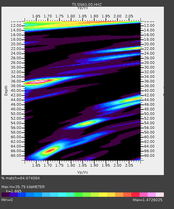
| Estimated Moho Depth: |
35.75 km |
| Estimated Crust Vp/Vs: |
1.66 |
| Assumed Crust Vp: |
5.738 km/s |
| Estimated Crust Vs: |
3.447 km/s |
| Estimated Crust Poisson's Ratio: |
0.22 |
|
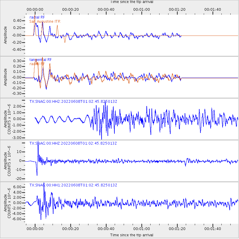
| Radial Match: |
84.874084 % |
| Radial Bump: |
333 |
| Transverse Match: |
69.82673 % |
| Transverse Bump: |
384 |
| SOD ConfigId: |
28208852 |
| Insert Time: |
2022-06-27 17:33:03.712 +0000 |
| GWidth: |
2.5 |
| Max Bumps: |
400 |
| Tol: |
0.001 |
|
Signal To Noise
| Channel | StoN | STA | LTA |
| TX:SNAG:00:HHZ:20220608T01:02:45.825013Z | 21.940945 | 6.3119355E-6 | 2.8767838E-7 |
| TX:SNAG:00:HH1:20220608T01:02:45.825013Z | 13.158146 | 2.046031E-6 | 1.5549539E-7 |
| TX:SNAG:00:HH2:20220608T01:02:45.825013Z | 2.6322825 | 8.306512E-7 | 3.1556308E-7 |
| Arrivals |
| Ps | 4.3 SECOND |
| PpPs | 16 SECOND |
| PsPs/PpSs | 20 SECOND |


