You are here: Home > Network List > TX - Texas Seismological Network Stations List
> Station WTFS Witchita Falls > Earthquake Result Viewer
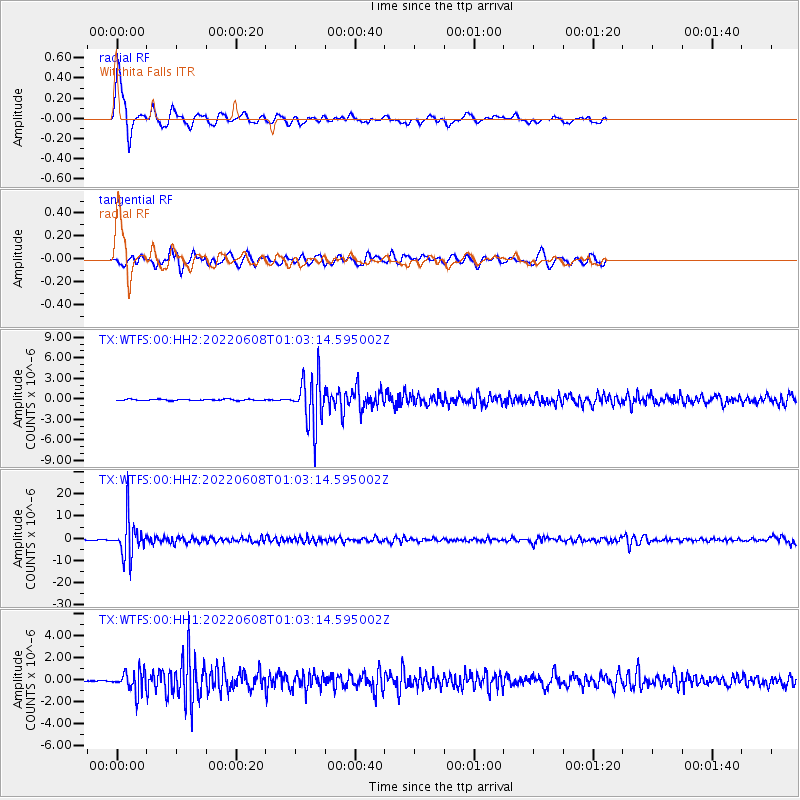
WTFS Witchita Falls - Earthquake Result Viewer

| Earthquake location: |
Peru-Brazil Border Region |
| Earthquake latitude/longitude: |
-9.0/-71.2 |
| Earthquake time(UTC): |
2022/06/08 (159) 00:55:47 GMT |
| Earthquake Depth: |
622 km |
| Earthquake Magnitude: |
6.5 Mww |
| Earthquake Catalog/Contributor: |
NEIC PDE/us |
|
| Network: |
TX Texas Seismological Network |
| Station: |
WTFS Witchita Falls |
| Lat/Lon: |
33.77 N/98.46 W |
| Elevation: |
277 m |
|
| Distance: |
49.8 deg |
| Az: |
330.029 deg |
| Baz: |
143.678 deg |
| Ray Param: |
0.06549016 |
| Estimated Moho Depth: |
40.25 km |
| Estimated Crust Vp/Vs: |
1.93 |
| Assumed Crust Vp: |
6.426 km/s |
| Estimated Crust Vs: |
3.334 km/s |
| Estimated Crust Poisson's Ratio: |
0.32 |
|
| Radial Match: |
85.03961 % |
| Radial Bump: |
384 |
| Transverse Match: |
70.27228 % |
| Transverse Bump: |
382 |
| SOD ConfigId: |
28208852 |
| Insert Time: |
2022-06-27 17:33:07.497 +0000 |
| GWidth: |
2.5 |
| Max Bumps: |
400 |
| Tol: |
0.001 |
|
Signal To Noise
| Channel | StoN | STA | LTA |
| TX:WTFS:00:HHZ:20220608T01:03:14.595002Z | 117.04627 | 8.592515E-6 | 7.3411265E-8 |
| TX:WTFS:00:HH1:20220608T01:03:14.595002Z | 8.741403 | 9.273624E-7 | 1.06088514E-7 |
| TX:WTFS:00:HH2:20220608T01:03:14.595002Z | 37.615604 | 3.5833723E-6 | 9.526292E-8 |
| Arrivals |
| Ps | 6.1 SECOND |
| PpPs | 17 SECOND |
| PsPs/PpSs | 24 SECOND |


