You are here: Home > Network List > UO - University of Oregon Regional Network Stations List
> Station TRASK Tillamook, OR, USA > Earthquake Result Viewer
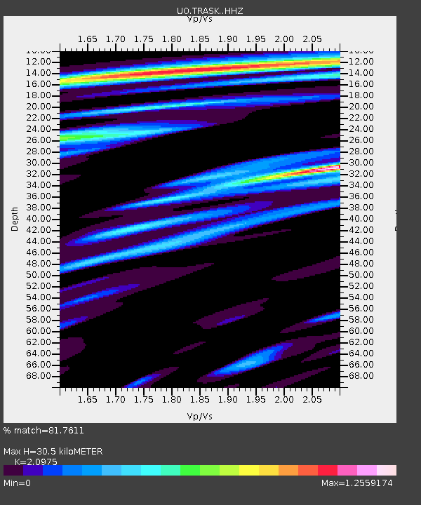
TRASK Tillamook, OR, USA - Earthquake Result Viewer
| Earthquake location: |
Peru-Brazil Border Region |
| Earthquake latitude/longitude: |
-9.0/-71.2 |
| Earthquake time(UTC): |
2022/06/08 (159) 00:55:47 GMT |
| Earthquake Depth: |
622 km |
| Earthquake Magnitude: |
6.5 Mww |
| Earthquake Catalog/Contributor: |
NEIC PDE/us |
|
| Network: |
UO University of Oregon Regional Network |
| Station: |
TRASK Tillamook, OR, USA |
| Lat/Lon: |
45.39 N/123.52 W |
| Elevation: |
786 m |
|
| Distance: |
71.7 deg |
| Az: |
324.009 deg |
| Baz: |
124.544 deg |
| Ray Param: |
0.05202049 |
| Estimated Moho Depth: |
30.5 km |
| Estimated Crust Vp/Vs: |
2.10 |
| Assumed Crust Vp: |
6.566 km/s |
| Estimated Crust Vs: |
3.13 km/s |
| Estimated Crust Poisson's Ratio: |
0.35 |
|
| Radial Match: |
81.7611 % |
| Radial Bump: |
400 |
| Transverse Match: |
73.519066 % |
| Transverse Bump: |
400 |
| SOD ConfigId: |
28208852 |
| Insert Time: |
2022-06-27 17:34:26.621 +0000 |
| GWidth: |
2.5 |
| Max Bumps: |
400 |
| Tol: |
0.001 |
|

Signal To Noise
| Channel | StoN | STA | LTA |
| UO:TRASK: :HHZ:20220608T01:05:36.860017Z | 18.4694 | 3.2469422E-6 | 1.7580116E-7 |
| UO:TRASK: :HHN:20220608T01:05:36.860017Z | 2.8916464 | 6.4481543E-7 | 2.2299248E-7 |
| UO:TRASK: :HHE:20220608T01:05:36.860017Z | 5.512515 | 1.0827265E-6 | 1.9641243E-7 |
| Arrivals |
| Ps | 5.2 SECOND |
| PpPs | 14 SECOND |
| PsPs/PpSs | 19 SECOND |


