You are here: Home > Network List > UW - Pacific Northwest Regional Seismic Network Stations List
> Station EPH2 Ephrata, WA, USA > Earthquake Result Viewer
EPH2 Ephrata, WA, USA - Earthquake Result Viewer
| Earthquake location: |
Peru-Brazil Border Region |
| Earthquake latitude/longitude: |
-9.0/-71.2 |
| Earthquake time(UTC): |
2022/06/08 (159) 00:55:47 GMT |
| Earthquake Depth: |
622 km |
| Earthquake Magnitude: |
6.5 Mww |
| Earthquake Catalog/Contributor: |
NEIC PDE/us |
|
| Network: |
UW Pacific Northwest Regional Seismic Network |
| Station: |
EPH2 Ephrata, WA, USA |
| Lat/Lon: |
47.37 N/119.61 W |
| Elevation: |
690 m |
|
| Distance: |
70.7 deg |
| Az: |
327.394 deg |
| Baz: |
128.46 deg |
| Ray Param: |
0.05266693 |
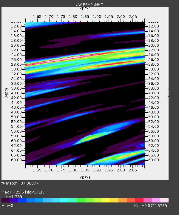
| Estimated Moho Depth: |
25.5 km |
| Estimated Crust Vp/Vs: |
1.75 |
| Assumed Crust Vp: |
6.419 km/s |
| Estimated Crust Vs: |
3.658 km/s |
| Estimated Crust Poisson's Ratio: |
0.26 |
|
| Radial Match: |
87.08877 % |
| Radial Bump: |
400 |
| Transverse Match: |
78.97574 % |
| Transverse Bump: |
400 |
| SOD ConfigId: |
28208852 |
| Insert Time: |
2022-06-27 17:37:30.063 +0000 |
| GWidth: |
2.5 |
| Max Bumps: |
400 |
| Tol: |
0.001 |
|

Signal To Noise
| Channel | StoN | STA | LTA |
| UW:EPH2: :HHZ:20220608T01:05:31.060029Z | 27.961363 | 3.1216396E-6 | 1.1164118E-7 |
| UW:EPH2: :HHN:20220608T01:05:31.060029Z | 6.807472 | 8.037569E-7 | 1.18069806E-7 |
| UW:EPH2: :HHE:20220608T01:05:31.060029Z | 17.14584 | 1.080557E-6 | 6.302153E-8 |
| Arrivals |
| Ps | 3.1 SECOND |
| PpPs | 11 SECOND |
| PsPs/PpSs | 14 SECOND |


