You are here: Home > Network List > AZ - ANZA Regional Network Stations List
> Station SOL AZ.SOL > Earthquake Result Viewer
SOL AZ.SOL - Earthquake Result Viewer
| Earthquake location: |
Bonin Islands, Japan Region |
| Earthquake latitude/longitude: |
26.3/140.5 |
| Earthquake time(UTC): |
1999/07/03 (184) 05:30:10 GMT |
| Earthquake Depth: |
431 km |
| Earthquake Magnitude: |
6.0 MB, 6.1 MW, 6.0 MW |
| Earthquake Catalog/Contributor: |
WHDF/NEIC |
|
| Network: |
AZ ANZA Regional Network |
| Station: |
SOL AZ.SOL |
| Lat/Lon: |
32.84 N/117.25 W |
| Elevation: |
245 m |
|
| Distance: |
85.6 deg |
| Az: |
55.597 deg |
| Baz: |
298.402 deg |
| Ray Param: |
0.043528784 |
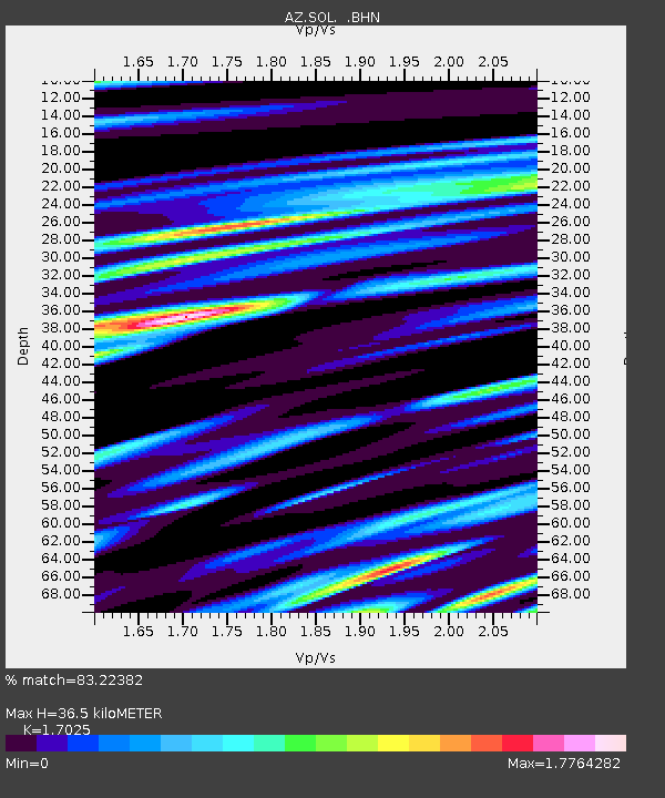
| Estimated Moho Depth: |
36.5 km |
| Estimated Crust Vp/Vs: |
1.70 |
| Assumed Crust Vp: |
6.264 km/s |
| Estimated Crust Vs: |
3.679 km/s |
| Estimated Crust Poisson's Ratio: |
0.24 |
|
| Radial Match: |
83.22382 % |
| Radial Bump: |
400 |
| Transverse Match: |
80.81844 % |
| Transverse Bump: |
400 |
| SOD ConfigId: |
32974 |
| Insert Time: |
2010-03-09 20:59:50.563 +0000 |
| GWidth: |
2.5 |
| Max Bumps: |
400 |
| Tol: |
0.001 |
|
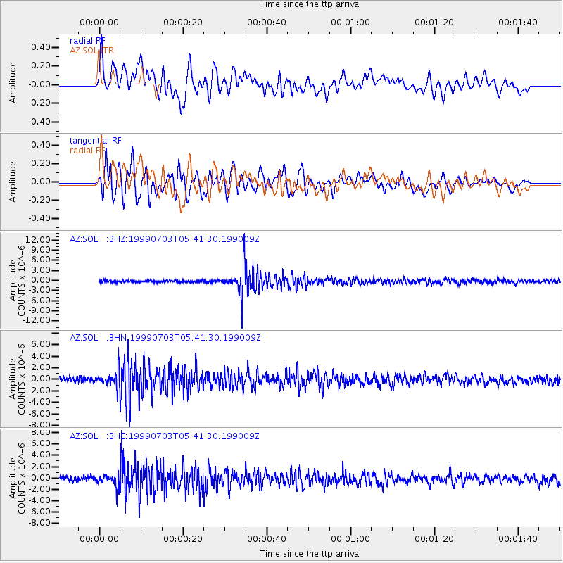
Signal To Noise
| Channel | StoN | STA | LTA |
| AZ:SOL: :BHN:19990703T05:41:30.199009Z | 3.2698934 | 1.2357609E-6 | 3.7792086E-7 |
| AZ:SOL: :BHE:19990703T05:41:30.199009Z | 2.4496012 | 1.0478584E-6 | 4.2776693E-7 |
| AZ:SOL: :BHZ:19990703T05:41:30.199009Z | 16.939825 | 4.045924E-6 | 2.3884095E-7 |
| Arrivals |
| Ps | 4.2 SECOND |
| PpPs | 15 SECOND |
| PsPs/PpSs | 20 SECOND |


