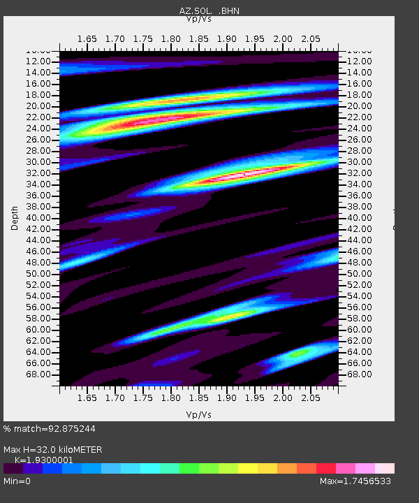
SOL AZ.SOL - Earthquake Result Viewer
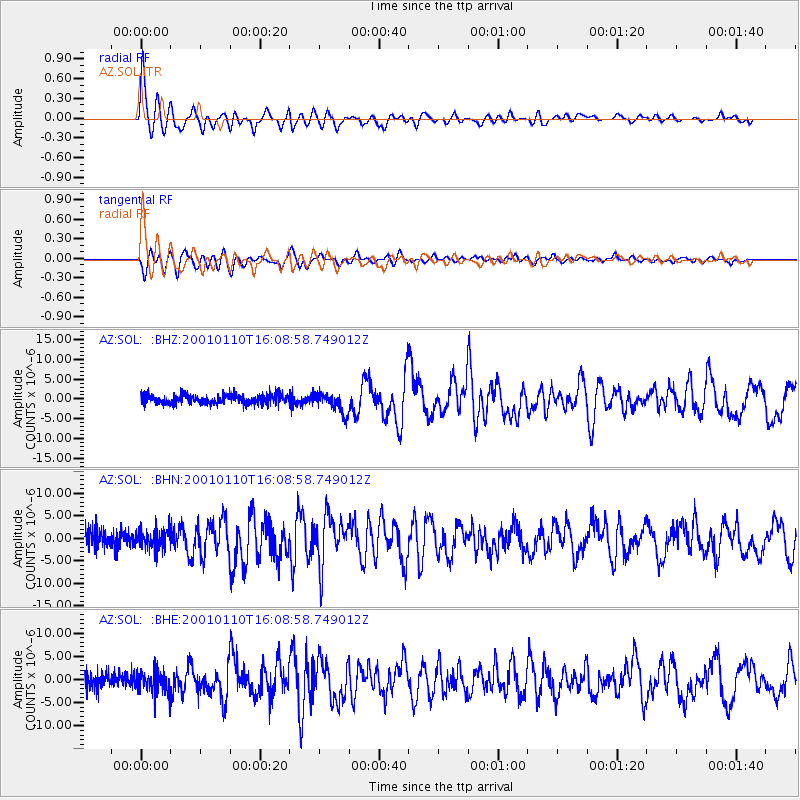
Earthquake location: Kodiak Island Region, Alaska
Earthquake latitude/longitude: 57.1/-153.2
Earthquake time(UTC): 2001/01/10 (010) 16:02:44 GMT
Earthquake Depth: 33 km
Earthquake Magnitude: 6.2 MB, 6.8 MS, 7.1 MW, 6.8 ML
Earthquake Catalog/Contributor: WHDF/NEIC
Network: AZ ANZA Regional Network
Station: SOL AZ.SOL
Lat/Lon: 32.84 N/117.25 W
Elevation: 245 m
Distance: 34.5 deg
Az: 119.181 deg
Baz: 325.504 deg
Ray Param: 0.0776563
Estimated Moho Depth: 32.0 km
Estimated Crust Vp/Vs: 1.93
Assumed Crust Vp: 6.264 km/s
Estimated Crust Vs: 3.245 km/s
Estimated Crust Poisson's Ratio: 0.32
Radial Match: 92.875244 %
Radial Bump: 400
Transverse Match: 81.10121 %
Transverse Bump: 400
SOD ConfigId: 3744
Insert Time: 2010-03-09 21:01:36.446 +0000
GWidth: 2.5
Max Bumps: 400
Tol: 0.001

Signal To Noise

ChannelStoNSTALTA
AZ:SOL: :BHN:20010110T16:08:58.749012Z1.26315192.1308942E-61.6869659E-6
AZ:SOL: :BHE:20010110T16:08:58.749012Z1.32132592.2966553E-61.7381445E-6
AZ:SOL: :BHZ:20010110T16:08:58.749012Z2.25585342.5349088E-61.1237028E-6
Arrivals
Ps5.1 SECOND
PpPs14 SECOND
PsPs/PpSs19 SECOND