You are here: Home > Network List > AZ - ANZA Regional Network Stations List
> Station SOL AZ.SOL > Earthquake Result Viewer
SOL AZ.SOL - Earthquake Result Viewer
| Earthquake location: |
Fiji Islands Region |
| Earthquake latitude/longitude: |
-21.7/-176.7 |
| Earthquake time(UTC): |
2001/07/04 (185) 07:06:31 GMT |
| Earthquake Depth: |
185 km |
| Earthquake Magnitude: |
5.9 MB, 5.8 MS, 6.5 MW, 6.5 MW |
| Earthquake Catalog/Contributor: |
WHDF/NEIC |
|
| Network: |
AZ ANZA Regional Network |
| Station: |
SOL AZ.SOL |
| Lat/Lon: |
32.84 N/117.25 W |
| Elevation: |
245 m |
|
| Distance: |
78.5 deg |
| Az: |
47.718 deg |
| Baz: |
234.803 deg |
| Ray Param: |
0.04913049 |
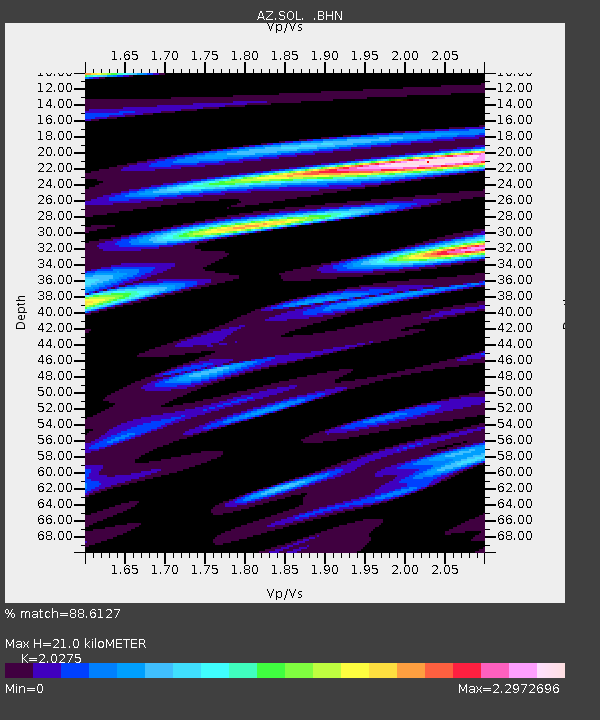
| Estimated Moho Depth: |
21.0 km |
| Estimated Crust Vp/Vs: |
2.03 |
| Assumed Crust Vp: |
6.264 km/s |
| Estimated Crust Vs: |
3.089 km/s |
| Estimated Crust Poisson's Ratio: |
0.34 |
|
| Radial Match: |
88.6127 % |
| Radial Bump: |
400 |
| Transverse Match: |
85.48551 % |
| Transverse Bump: |
400 |
| SOD ConfigId: |
4714 |
| Insert Time: |
2010-03-09 21:01:51.343 +0000 |
| GWidth: |
2.5 |
| Max Bumps: |
400 |
| Tol: |
0.001 |
|

Signal To Noise
| Channel | StoN | STA | LTA |
| AZ:SOL: :BHN:20010704T07:17:41.225Z | 1.7223438 | 6.151146E-7 | 3.5713808E-7 |
| AZ:SOL: :BHE:20010704T07:17:41.225Z | 1.349963 | 4.4465963E-7 | 3.2938652E-7 |
| AZ:SOL: :BHZ:20010704T07:17:41.225Z | 5.471655 | 1.2782548E-6 | 2.3361395E-7 |
| Arrivals |
| Ps | 3.5 SECOND |
| PpPs | 9.9 SECOND |
| PsPs/PpSs | 13 SECOND |


