You are here: Home > Network List > AZ - ANZA Regional Network Stations List
> Station SOL AZ.SOL > Earthquake Result Viewer
SOL AZ.SOL - Earthquake Result Viewer
| Earthquake location: |
Central Alaska |
| Earthquake latitude/longitude: |
63.5/-147.9 |
| Earthquake time(UTC): |
2002/10/23 (296) 11:27:19 GMT |
| Earthquake Depth: |
4.2 km |
| Earthquake Magnitude: |
6.0 MB, 6.7 MS, 6.7 MW, 6.7 MW |
| Earthquake Catalog/Contributor: |
WHDF/NEIC |
|
| Network: |
AZ ANZA Regional Network |
| Station: |
SOL AZ.SOL |
| Lat/Lon: |
32.84 N/117.25 W |
| Elevation: |
245 m |
|
| Distance: |
36.2 deg |
| Az: |
133.346 deg |
| Baz: |
337.211 deg |
| Ray Param: |
0.07683315 |
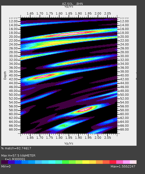
| Estimated Moho Depth: |
57.5 km |
| Estimated Crust Vp/Vs: |
1.93 |
| Assumed Crust Vp: |
6.264 km/s |
| Estimated Crust Vs: |
3.245 km/s |
| Estimated Crust Poisson's Ratio: |
0.32 |
|
| Radial Match: |
92.74617 % |
| Radial Bump: |
400 |
| Transverse Match: |
79.6636 % |
| Transverse Bump: |
400 |
| SOD ConfigId: |
4714 |
| Insert Time: |
2010-03-09 21:01:59.653 +0000 |
| GWidth: |
2.5 |
| Max Bumps: |
400 |
| Tol: |
0.001 |
|

Signal To Noise
| Channel | StoN | STA | LTA |
| AZ:SOL: :BHN:20021023T11:33:52.156013Z | 2.839333 | 1.1076477E-6 | 3.9010837E-7 |
| AZ:SOL: :BHE:20021023T11:33:52.156013Z | 1.5302113 | 9.100257E-7 | 5.947059E-7 |
| AZ:SOL: :BHZ:20021023T11:33:52.156013Z | 3.8669267 | 1.7452089E-6 | 4.513168E-7 |
| Arrivals |
| Ps | 9.1 SECOND |
| PpPs | 25 SECOND |
| PsPs/PpSs | 34 SECOND |


