You are here: Home > Network List > AZ - ANZA Regional Network Stations List
> Station SOL AZ.SOL > Earthquake Result Viewer
SOL AZ.SOL - Earthquake Result Viewer
| Earthquake location: |
Hokkaido, Japan Region |
| Earthquake latitude/longitude: |
42.6/144.6 |
| Earthquake time(UTC): |
2003/10/08 (281) 09:06:55 GMT |
| Earthquake Depth: |
32 km |
| Earthquake Magnitude: |
6.0 MB, 6.6 MS, 6.7 MW, 6.6 MW |
| Earthquake Catalog/Contributor: |
WHDF/NEIC |
|
| Network: |
AZ ANZA Regional Network |
| Station: |
SOL AZ.SOL |
| Lat/Lon: |
32.84 N/117.25 W |
| Elevation: |
245 m |
|
| Distance: |
74.0 deg |
| Az: |
60.103 deg |
| Baz: |
310.555 deg |
| Ray Param: |
0.052594233 |
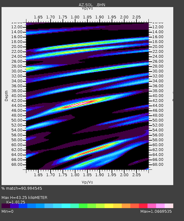
| Estimated Moho Depth: |
43.25 km |
| Estimated Crust Vp/Vs: |
1.81 |
| Assumed Crust Vp: |
6.264 km/s |
| Estimated Crust Vs: |
3.456 km/s |
| Estimated Crust Poisson's Ratio: |
0.28 |
|
| Radial Match: |
90.994545 % |
| Radial Bump: |
400 |
| Transverse Match: |
84.63826 % |
| Transverse Bump: |
400 |
| SOD ConfigId: |
32974 |
| Insert Time: |
2010-03-09 21:02:08.783 +0000 |
| GWidth: |
2.5 |
| Max Bumps: |
400 |
| Tol: |
0.001 |
|

Signal To Noise
| Channel | StoN | STA | LTA |
| AZ:SOL: :BHN:20031008T09:17:56.639011Z | 0.74407893 | 3.1017004E-7 | 4.1685098E-7 |
| AZ:SOL: :BHE:20031008T09:17:56.639011Z | 1.6581866 | 5.6330595E-7 | 3.3971205E-7 |
| AZ:SOL: :BHZ:20031008T09:17:56.639011Z | 3.7013552 | 9.744889E-7 | 2.6327893E-7 |
| Arrivals |
| Ps | 5.8 SECOND |
| PpPs | 19 SECOND |
| PsPs/PpSs | 25 SECOND |


