You are here: Home > Network List > AZ - ANZA Regional Network Stations List
> Station SOL AZ.SOL > Earthquake Result Viewer
SOL AZ.SOL - Earthquake Result Viewer
| Earthquake location: |
Guatemala |
| Earthquake latitude/longitude: |
14.0/-91.1 |
| Earthquake time(UTC): |
2003/08/25 (237) 06:28:35 GMT |
| Earthquake Depth: |
100 km |
| Earthquake Magnitude: |
5.4 MB, 5.9 MW, 5.9 MW |
| Earthquake Catalog/Contributor: |
WHDF/NEIC |
|
| Network: |
AZ ANZA Regional Network |
| Station: |
SOL AZ.SOL |
| Lat/Lon: |
32.84 N/117.25 W |
| Elevation: |
245 m |
|
| Distance: |
30.3 deg |
| Az: |
312.623 deg |
| Baz: |
121.97 deg |
| Ray Param: |
0.07920033 |
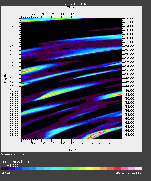
| Estimated Moho Depth: |
68.0 km |
| Estimated Crust Vp/Vs: |
1.97 |
| Assumed Crust Vp: |
6.264 km/s |
| Estimated Crust Vs: |
3.188 km/s |
| Estimated Crust Poisson's Ratio: |
0.33 |
|
| Radial Match: |
85.90868 % |
| Radial Bump: |
400 |
| Transverse Match: |
75.44599 % |
| Transverse Bump: |
400 |
| SOD ConfigId: |
32974 |
| Insert Time: |
2010-03-09 21:02:11.282 +0000 |
| GWidth: |
2.5 |
| Max Bumps: |
400 |
| Tol: |
0.001 |
|

Signal To Noise
| Channel | StoN | STA | LTA |
| AZ:SOL: :BHN:20030825T06:34:06.94001Z | 1.0432597 | 4.9613544E-7 | 4.7556273E-7 |
| AZ:SOL: :BHE:20030825T06:34:06.94001Z | 2.9061792 | 1.1805032E-6 | 4.0620455E-7 |
| AZ:SOL: :BHZ:20030825T06:34:06.94001Z | 5.696682 | 1.7361675E-6 | 3.047682E-7 |
| Arrivals |
| Ps | 11 SECOND |
| PpPs | 30 SECOND |
| PsPs/PpSs | 41 SECOND |


