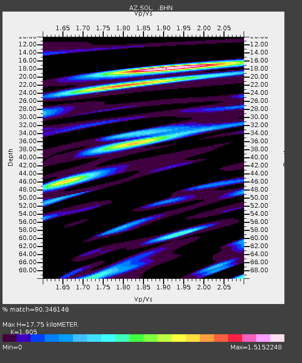
SOL AZ.SOL - Earthquake Result Viewer

Earthquake location: Rat Islands, Aleutian Islands
Earthquake latitude/longitude: 51.4/176.8
Earthquake time(UTC): 2003/06/23 (174) 12:12:34 GMT
Earthquake Depth: 20 km
Earthquake Magnitude: 6.3 MB, 7.0 MS, 6.9 MW, 6.8 MW
Earthquake Catalog/Contributor: WHDF/NEIC
Network: AZ ANZA Regional Network
Station: SOL AZ.SOL
Lat/Lon: 32.84 N/117.25 W
Elevation: 245 m
Distance: 50.5 deg
Az: 84.764 deg
Baz: 312.234 deg
Ray Param: 0.06796118
Estimated Moho Depth: 17.75 km
Estimated Crust Vp/Vs: 1.90
Assumed Crust Vp: 6.264 km/s
Estimated Crust Vs: 3.288 km/s
Estimated Crust Poisson's Ratio: 0.31
Radial Match: 90.346146 %
Radial Bump: 400
Transverse Match: 87.235405 %
Transverse Bump: 400
SOD ConfigId: 32974
Insert Time: 2010-03-09 21:02:19.096 +0000
GWidth: 2.5
Max Bumps: 400
Tol: 0.001

Signal To Noise

ChannelStoNSTALTA
AZ:SOL: :BHN:20030623T12:21:00.506987Z1.87053696.667385E-73.564423E-7
AZ:SOL: :BHE:20030623T12:21:00.506987Z1.86507366.914158E-73.7071771E-7
AZ:SOL: :BHZ:20030623T12:21:00.506987Z6.62818241.3876928E-62.093625E-7
Arrivals
Ps2.7 SECOND
PpPs7.8 SECOND
PsPs/PpSs11 SECOND