You are here: Home > Network List > AZ - ANZA Regional Network Stations List
> Station SOL AZ.SOL > Earthquake Result Viewer
SOL AZ.SOL - Earthquake Result Viewer
| Earthquake location: |
Near Coast Of Guatemala |
| Earthquake latitude/longitude: |
13.6/-90.8 |
| Earthquake time(UTC): |
2003/01/21 (021) 02:46:47 GMT |
| Earthquake Depth: |
24 km |
| Earthquake Magnitude: |
5.5 MB, 6.3 MS, 6.5 MW, 6.3 MW |
| Earthquake Catalog/Contributor: |
WHDF/NEIC |
|
| Network: |
AZ ANZA Regional Network |
| Station: |
SOL AZ.SOL |
| Lat/Lon: |
32.84 N/117.25 W |
| Elevation: |
245 m |
|
| Distance: |
30.8 deg |
| Az: |
312.868 deg |
| Baz: |
122.173 deg |
| Ray Param: |
0.07921913 |
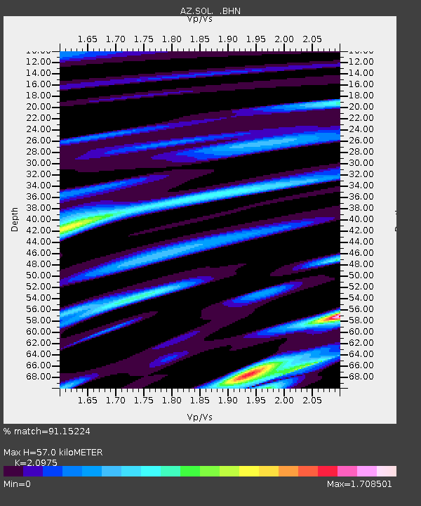
| Estimated Moho Depth: |
57.0 km |
| Estimated Crust Vp/Vs: |
2.10 |
| Assumed Crust Vp: |
6.264 km/s |
| Estimated Crust Vs: |
2.986 km/s |
| Estimated Crust Poisson's Ratio: |
0.35 |
|
| Radial Match: |
91.15224 % |
| Radial Bump: |
400 |
| Transverse Match: |
82.1892 % |
| Transverse Bump: |
400 |
| SOD ConfigId: |
32974 |
| Insert Time: |
2010-03-09 21:02:26.633 +0000 |
| GWidth: |
2.5 |
| Max Bumps: |
400 |
| Tol: |
0.001 |
|

Signal To Noise
| Channel | StoN | STA | LTA |
| AZ:SOL: :BHN:20030121T02:52:30.949991Z | 1.179898 | 6.025152E-7 | 5.1065024E-7 |
| AZ:SOL: :BHE:20030121T02:52:30.949991Z | 1.2800637 | 6.4021833E-7 | 5.001457E-7 |
| AZ:SOL: :BHZ:20030121T02:52:30.949991Z | 4.7292514 | 1.7085619E-6 | 3.612753E-7 |
| Arrivals |
| Ps | 11 SECOND |
| PpPs | 26 SECOND |
| PsPs/PpSs | 37 SECOND |


