You are here: Home > Network List > AZ - ANZA Regional Network Stations List
> Station SOL AZ.SOL > Earthquake Result Viewer
SOL AZ.SOL - Earthquake Result Viewer
| Earthquake location: |
Solomon Islands |
| Earthquake latitude/longitude: |
-10.5/160.8 |
| Earthquake time(UTC): |
2003/01/20 (020) 08:43:06 GMT |
| Earthquake Depth: |
33 km |
| Earthquake Magnitude: |
6.7 MB, 7.8 MS, 7.3 MW, 7.2 MW |
| Earthquake Catalog/Contributor: |
WHDF/NEIC |
|
| Network: |
AZ ANZA Regional Network |
| Station: |
SOL AZ.SOL |
| Lat/Lon: |
32.84 N/117.25 W |
| Elevation: |
245 m |
|
| Distance: |
89.0 deg |
| Az: |
56.484 deg |
| Baz: |
256.917 deg |
| Ray Param: |
0.04214471 |
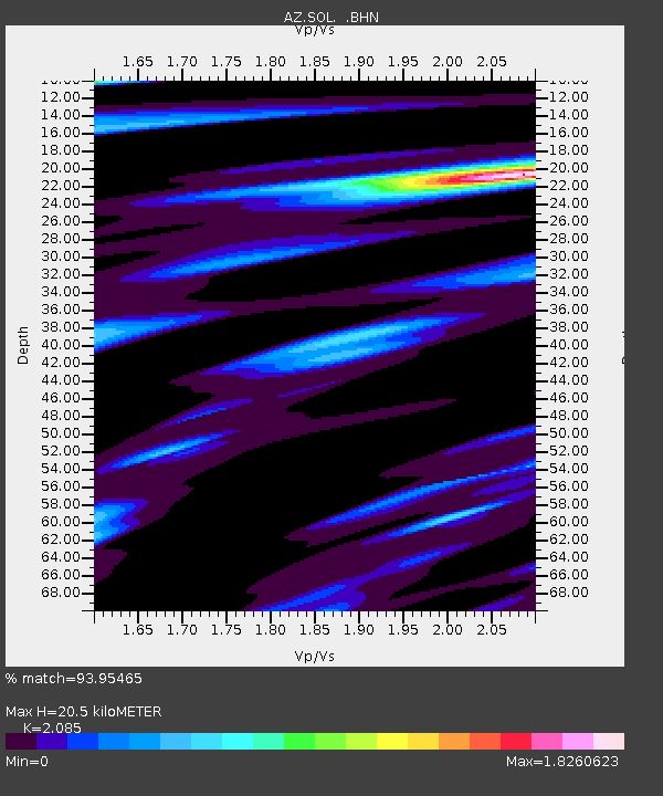
| Estimated Moho Depth: |
20.5 km |
| Estimated Crust Vp/Vs: |
2.09 |
| Assumed Crust Vp: |
6.264 km/s |
| Estimated Crust Vs: |
3.004 km/s |
| Estimated Crust Poisson's Ratio: |
0.35 |
|
| Radial Match: |
93.95465 % |
| Radial Bump: |
400 |
| Transverse Match: |
90.47471 % |
| Transverse Bump: |
400 |
| SOD ConfigId: |
32974 |
| Insert Time: |
2010-03-09 21:02:29.202 +0000 |
| GWidth: |
2.5 |
| Max Bumps: |
400 |
| Tol: |
0.001 |
|

Signal To Noise
| Channel | StoN | STA | LTA |
| AZ:SOL: :BHN:20030120T08:55:26.176018Z | 1.2040917 | 3.4815145E-7 | 2.891403E-7 |
| AZ:SOL: :BHE:20030120T08:55:26.176018Z | 0.64465404 | 3.521984E-7 | 5.463371E-7 |
| AZ:SOL: :BHZ:20030120T08:55:26.176018Z | 7.18696 | 1.77759E-6 | 2.4733544E-7 |
| Arrivals |
| Ps | 3.6 SECOND |
| PpPs | 9.9 SECOND |
| PsPs/PpSs | 14 SECOND |


