You are here: Home > Network List > AZ - ANZA Regional Network Stations List
> Station SOL AZ.SOL > Earthquake Result Viewer
SOL AZ.SOL - Earthquake Result Viewer
| Earthquake location: |
Unimak Island Region, Alaska |
| Earthquake latitude/longitude: |
54.5/-163.9 |
| Earthquake time(UTC): |
2004/06/04 (156) 01:48:03 GMT |
| Earthquake Depth: |
73 km |
| Earthquake Magnitude: |
5.2 MB, 5.6 MW, 5.5 MW |
| Earthquake Catalog/Contributor: |
WHDF/NEIC |
|
| Network: |
AZ ANZA Regional Network |
| Station: |
SOL AZ.SOL |
| Lat/Lon: |
32.84 N/117.25 W |
| Elevation: |
245 m |
|
| Distance: |
39.1 deg |
| Az: |
104.172 deg |
| Baz: |
317.748 deg |
| Ray Param: |
0.074949786 |
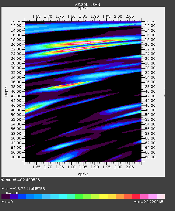
| Estimated Moho Depth: |
18.75 km |
| Estimated Crust Vp/Vs: |
1.88 |
| Assumed Crust Vp: |
6.264 km/s |
| Estimated Crust Vs: |
3.332 km/s |
| Estimated Crust Poisson's Ratio: |
0.30 |
|
| Radial Match: |
82.498535 % |
| Radial Bump: |
400 |
| Transverse Match: |
69.06386 % |
| Transverse Bump: |
400 |
| SOD ConfigId: |
32974 |
| Insert Time: |
2010-03-09 21:02:38.841 +0000 |
| GWidth: |
2.5 |
| Max Bumps: |
400 |
| Tol: |
0.001 |
|

Signal To Noise
| Channel | StoN | STA | LTA |
| AZ:SOL: :BHN:20040604T01:54:53.098986Z | 2.543408 | 2.017457E-6 | 7.932102E-7 |
| AZ:SOL: :BHE:20040604T01:54:53.098986Z | 3.4237878 | 2.360881E-6 | 6.8955234E-7 |
| AZ:SOL: :BHZ:20040604T01:54:53.098986Z | 5.579437 | 3.2363607E-6 | 5.800515E-7 |
| Arrivals |
| Ps | 2.8 SECOND |
| PpPs | 8.1 SECOND |
| PsPs/PpSs | 11 SECOND |


