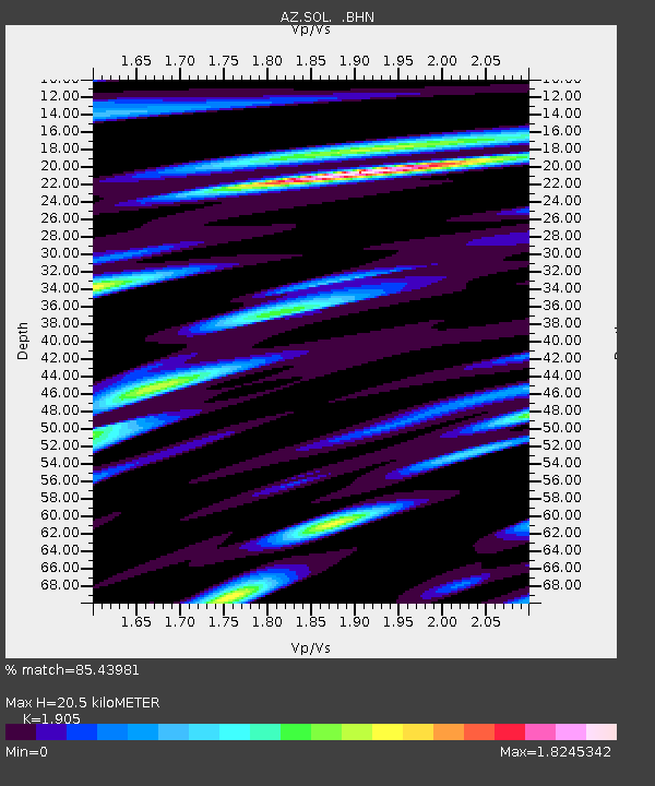
SOL AZ.SOL - Earthquake Result Viewer

Earthquake location: South Of Aleutian Islands
Earthquake latitude/longitude: 51.8/-166.3
Earthquake time(UTC): 2004/08/07 (220) 09:30:16 GMT
Earthquake Depth: 8.0 km
Earthquake Magnitude: 6.3 MB, 5.4 MS, 6.0 MW, 6.0 MW
Earthquake Catalog/Contributor: WHDF/NEIC
Network: AZ ANZA Regional Network
Station: SOL AZ.SOL
Lat/Lon: 32.84 N/117.25 W
Elevation: 245 m
Distance: 40.0 deg
Az: 98.632 deg
Baz: 313.11 deg
Ray Param: 0.07463421
Estimated Moho Depth: 20.5 km
Estimated Crust Vp/Vs: 1.90
Assumed Crust Vp: 6.264 km/s
Estimated Crust Vs: 3.288 km/s
Estimated Crust Poisson's Ratio: 0.31
Radial Match: 85.43981 %
Radial Bump: 400
Transverse Match: 78.24915 %
Transverse Bump: 400
SOD ConfigId: 2459
Insert Time: 2010-03-09 21:02:53.605 +0000
GWidth: 2.5
Max Bumps: 400
Tol: 0.001

Signal To Noise

ChannelStoNSTALTA
AZ:SOL: :BHN:20040807T09:37:21.501005Z4.3655771.0032309E-62.2980485E-7
AZ:SOL: :BHE:20040807T09:37:21.501005Z6.4655411.3678592E-62.1156146E-7
AZ:SOL: :BHZ:20040807T09:37:21.501005Z13.363722.166688E-61.621321E-7
Arrivals
Ps3.2 SECOND
PpPs8.9 SECOND
PsPs/PpSs12 SECOND