You are here: Home > Network List > AZ - ANZA Regional Network Stations List
> Station SOL AZ.SOL > Earthquake Result Viewer
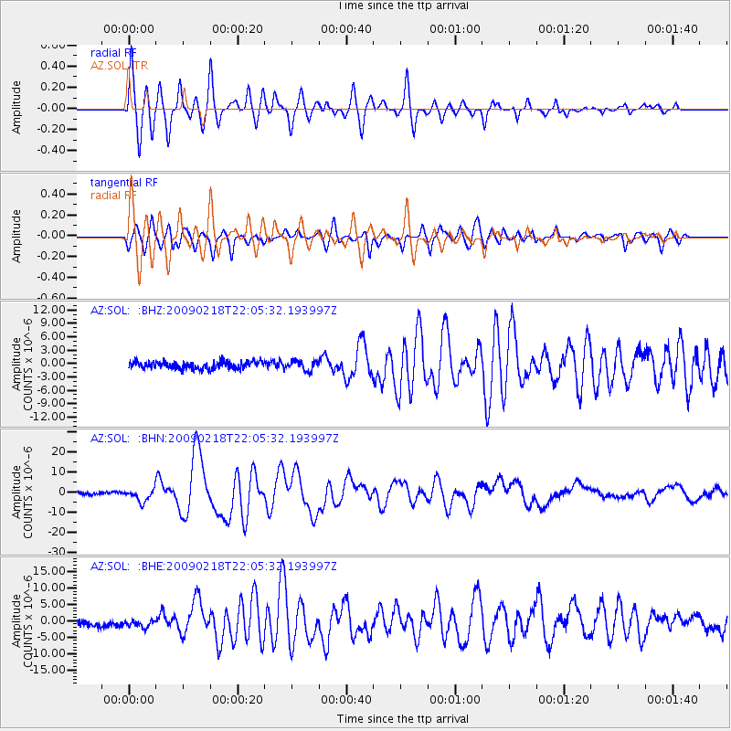
SOL AZ.SOL - Earthquake Result Viewer

| Earthquake location: |
Kermadec Islands Region |
| Earthquake latitude/longitude: |
-27.4/-176.3 |
| Earthquake time(UTC): |
2009/02/18 (049) 21:53:45 GMT |
| Earthquake Depth: |
25 km |
| Earthquake Magnitude: |
6.8 MB, 7.2 MS, 6.9 MW, 6.9 MW |
| Earthquake Catalog/Contributor: |
WHDF/NEIC |
|
| Network: |
AZ ANZA Regional Network |
| Station: |
SOL AZ.SOL |
| Lat/Lon: |
32.84 N/117.25 W |
| Elevation: |
245 m |
|
| Distance: |
82.1 deg |
| Az: |
46.812 deg |
| Baz: |
230.341 deg |
| Ray Param: |
0.047084037 |
| Estimated Moho Depth: |
31.25 km |
| Estimated Crust Vp/Vs: |
2.09 |
| Assumed Crust Vp: |
6.264 km/s |
| Estimated Crust Vs: |
3.001 km/s |
| Estimated Crust Poisson's Ratio: |
0.35 |
|
| Radial Match: |
90.74331 % |
| Radial Bump: |
400 |
| Transverse Match: |
84.837395 % |
| Transverse Bump: |
400 |
| SOD ConfigId: |
2658 |
| Insert Time: |
2010-03-09 21:03:04.564 +0000 |
| GWidth: |
2.5 |
| Max Bumps: |
400 |
| Tol: |
0.001 |
|
Signal To Noise
| Channel | StoN | STA | LTA |
| AZ:SOL: :BHN:20090218T22:05:32.193997Z | 5.6694794 | 3.1684594E-6 | 5.588625E-7 |
| AZ:SOL: :BHE:20090218T22:05:32.193997Z | 1.3233972 | 1.1442293E-6 | 8.646151E-7 |
| AZ:SOL: :BHZ:20090218T22:05:32.193997Z | 1.3432827 | 1.0980746E-6 | 8.174561E-7 |
| Arrivals |
| Ps | 5.5 SECOND |
| PpPs | 15 SECOND |
| PsPs/PpSs | 21 SECOND |


