You are here: Home > Network List > AZ - ANZA Regional Network Stations List
> Station SOL AZ.SOL > Earthquake Result Viewer
SOL AZ.SOL - Earthquake Result Viewer
| Earthquake location: |
Fiji Islands Region |
| Earthquake latitude/longitude: |
-14.4/-177.3 |
| Earthquake time(UTC): |
2005/08/07 (219) 11:35:26 GMT |
| Earthquake Depth: |
10 km |
| Earthquake Magnitude: |
5.7 MB, 5.9 MS, 6.0 MW, 6.0 MW |
| Earthquake Catalog/Contributor: |
WHDF/NEIC |
|
| Network: |
AZ ANZA Regional Network |
| Station: |
SOL AZ.SOL |
| Lat/Lon: |
32.84 N/117.25 W |
| Elevation: |
245 m |
|
| Distance: |
74.1 deg |
| Az: |
49.312 deg |
| Baz: |
240.763 deg |
| Ray Param: |
0.052537885 |
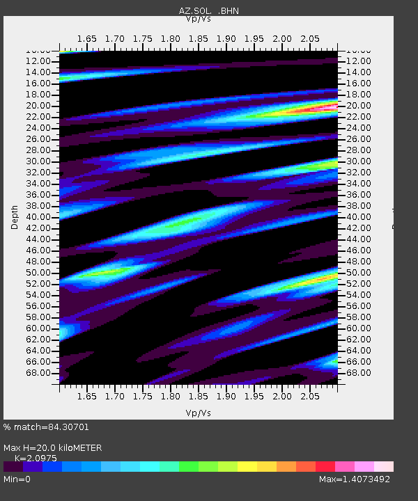
| Estimated Moho Depth: |
20.0 km |
| Estimated Crust Vp/Vs: |
2.10 |
| Assumed Crust Vp: |
6.264 km/s |
| Estimated Crust Vs: |
2.986 km/s |
| Estimated Crust Poisson's Ratio: |
0.35 |
|
| Radial Match: |
84.30701 % |
| Radial Bump: |
400 |
| Transverse Match: |
74.01343 % |
| Transverse Bump: |
400 |
| SOD ConfigId: |
2669 |
| Insert Time: |
2010-03-09 21:03:06.305 +0000 |
| GWidth: |
2.5 |
| Max Bumps: |
400 |
| Tol: |
0.001 |
|

Signal To Noise
| Channel | StoN | STA | LTA |
| AZ:SOL: :BHN:20050807T11:46:31.272019Z | 0.729378 | 2.513544E-7 | 3.4461473E-7 |
| AZ:SOL: :BHE:20050807T11:46:31.272019Z | 0.7195277 | 2.4905805E-7 | 3.46141E-7 |
| AZ:SOL: :BHZ:20050807T11:46:31.272019Z | 2.0346336 | 3.4789196E-7 | 1.7098506E-7 |
| Arrivals |
| Ps | 3.6 SECOND |
| PpPs | 9.6 SECOND |
| PsPs/PpSs | 13 SECOND |


