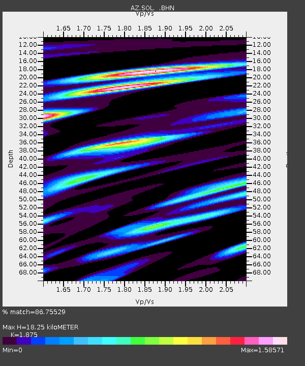
SOL AZ.SOL - Earthquake Result Viewer

Earthquake location: Unimak Island Region, Alaska
Earthquake latitude/longitude: 53.8/-164.1
Earthquake time(UTC): 2005/11/20 (324) 12:53:02 GMT
Earthquake Depth: 30 km
Earthquake Magnitude: 5.7 MB, 5.8 MS, 6.2 MW, 6.0 MW
Earthquake Catalog/Contributor: WHDF/NEIC
Network: AZ ANZA Regional Network
Station: SOL AZ.SOL
Lat/Lon: 32.84 N/117.25 W
Elevation: 245 m
Distance: 39.1 deg
Az: 103.193 deg
Baz: 316.738 deg
Ray Param: 0.075120844
Estimated Moho Depth: 18.25 km
Estimated Crust Vp/Vs: 1.88
Assumed Crust Vp: 6.264 km/s
Estimated Crust Vs: 3.341 km/s
Estimated Crust Poisson's Ratio: 0.30
Radial Match: 86.75529 %
Radial Bump: 400
Transverse Match: 81.88684 %
Transverse Bump: 400
SOD ConfigId: 2448
Insert Time: 2010-03-09 21:03:12.140 +0000
GWidth: 2.5
Max Bumps: 400
Tol: 0.001

Signal To Noise

ChannelStoNSTALTA
AZ:SOL: :BHN:20051120T12:59:56.97301Z1.4704143.5086157E-72.3861412E-7
AZ:SOL: :BHE:20051120T12:59:56.97301Z1.34575383.8690163E-72.874981E-7
AZ:SOL: :BHZ:20051120T12:59:56.97301Z3.2118334.3745078E-71.3619973E-7
Arrivals
Ps2.7 SECOND
PpPs7.9 SECOND
PsPs/PpSs11 SECOND