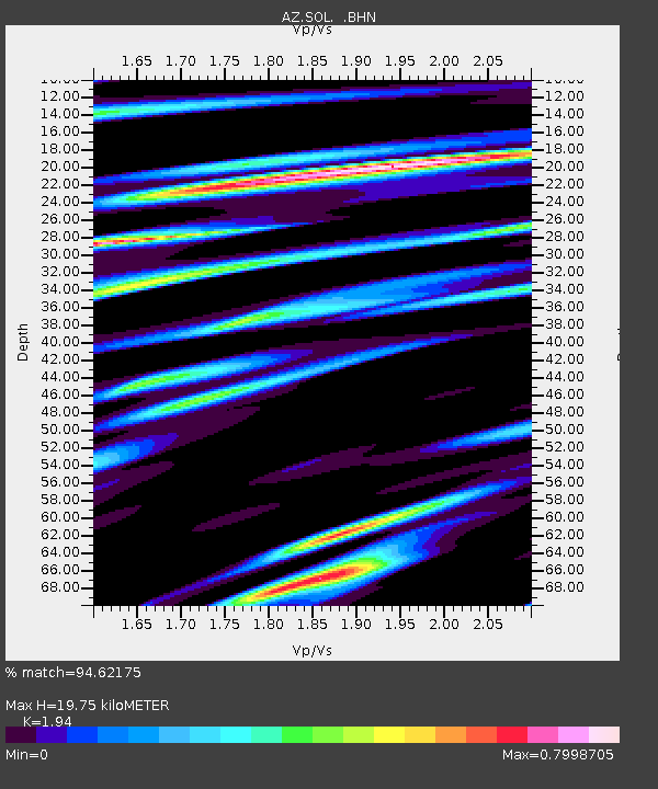
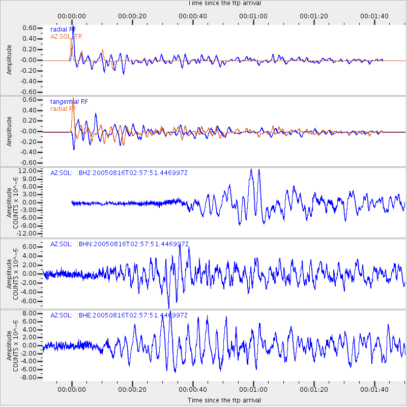
SOL AZ.SOL - Earthquake Result Viewer

Earthquake location: Near East Coast Of Honshu, Japan
Earthquake latitude/longitude: 38.3/142.0
Earthquake time(UTC): 2005/08/16 (228) 02:46:28 GMT
Earthquake Depth: 36 km
Earthquake Magnitude: 6.5 MB, 6.8 MS, 7.2 MW, 7.1 MW
Earthquake Catalog/Contributor: WHDF/NEIC
Network: AZ ANZA Regional Network
Station: SOL AZ.SOL
Lat/Lon: 32.84 N/117.25 W
Elevation: 245 m
Distance: 77.9 deg
Az: 57.778 deg
Baz: 307.727 deg
Ray Param: 0.049961727
Estimated Moho Depth: 19.75 km
Estimated Crust Vp/Vs: 1.94
Assumed Crust Vp: 6.264 km/s
Estimated Crust Vs: 3.229 km/s
Estimated Crust Poisson's Ratio: 0.32
Radial Match: 94.62175 %
Radial Bump: 400
Transverse Match: 93.1659 %
Transverse Bump: 400
SOD ConfigId: 2475
Insert Time: 2010-03-09 21:03:17.123 +0000
GWidth: 2.5
Max Bumps: 400
Tol: 0.001

Signal To Noise

ChannelStoNSTALTA
AZ:SOL: :BHN:20050816T02:57:51.446997Z1.10223914.4284693E-74.0177028E-7
AZ:SOL: :BHE:20050816T02:57:51.446997Z1.49111445.568638E-73.734548E-7
AZ:SOL: :BHZ:20050816T02:57:51.446997Z2.39753086.7711306E-72.82421E-7
Arrivals
Ps3.0 SECOND
PpPs9.0 SECOND
PsPs/PpSs12 SECOND