You are here: Home > Network List > AZ - ANZA Regional Network Stations List
> Station SOL AZ.SOL > Earthquake Result Viewer
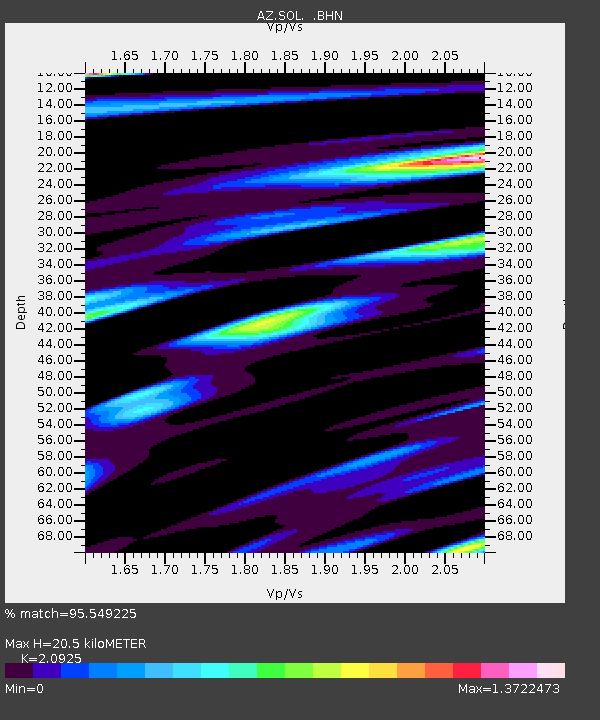
SOL AZ.SOL - Earthquake Result Viewer
| Earthquake location: |
New Ireland Region, P.N.G. |
| Earthquake latitude/longitude: |
-4.5/153.5 |
| Earthquake time(UTC): |
2005/09/09 (252) 07:26:43 GMT |
| Earthquake Depth: |
90 km |
| Earthquake Magnitude: |
6.3 MB, 7.7 MW, 7.5 MW |
| Earthquake Catalog/Contributor: |
WHDF/NEIC |
|
| Network: |
AZ ANZA Regional Network |
| Station: |
SOL AZ.SOL |
| Lat/Lon: |
32.84 N/117.25 W |
| Elevation: |
245 m |
|
| Distance: |
91.8 deg |
| Az: |
57.372 deg |
| Baz: |
265.814 deg |
| Ray Param: |
0.041514717 |
| Estimated Moho Depth: |
20.5 km |
| Estimated Crust Vp/Vs: |
2.09 |
| Assumed Crust Vp: |
6.264 km/s |
| Estimated Crust Vs: |
2.993 km/s |
| Estimated Crust Poisson's Ratio: |
0.35 |
|
| Radial Match: |
95.549225 % |
| Radial Bump: |
374 |
| Transverse Match: |
93.62403 % |
| Transverse Bump: |
400 |
| SOD ConfigId: |
2475 |
| Insert Time: |
2010-03-09 21:03:21.054 +0000 |
| GWidth: |
2.5 |
| Max Bumps: |
400 |
| Tol: |
0.001 |
|

Signal To Noise
| Channel | StoN | STA | LTA |
| AZ:SOL: :BHN:20050909T07:39:10.39803Z | 0.98570734 | 3.973033E-7 | 4.0306415E-7 |
| AZ:SOL: :BHE:20050909T07:39:10.39803Z | 2.0026937 | 6.6827005E-7 | 3.3368562E-7 |
| AZ:SOL: :BHZ:20050909T07:39:10.39803Z | 6.7557535 | 1.44446E-6 | 2.1381183E-7 |
| Arrivals |
| Ps | 3.6 SECOND |
| PpPs | 10.0 SECOND |
| PsPs/PpSs | 14 SECOND |


