You are here: Home > Network List > AZ - ANZA Regional Network Stations List
> Station SOL AZ.SOL > Earthquake Result Viewer
SOL AZ.SOL - Earthquake Result Viewer

| Earthquake location: |
Easter Island Region |
| Earthquake latitude/longitude: |
-22.1/-113.4 |
| Earthquake time(UTC): |
1996/09/05 (249) 08:14:14 GMT |
| Earthquake Depth: |
10 km |
| Earthquake Magnitude: |
6.2 MB, 7.0 MS, 7.0 UNKNOWN, 6.9 MW |
| Earthquake Catalog/Contributor: |
WHDF/NEIC |
|
| Network: |
AZ ANZA Regional Network |
| Station: |
SOL AZ.SOL |
| Lat/Lon: |
32.84 N/117.25 W |
| Elevation: |
245 m |
|
| Distance: |
54.8 deg |
| Az: |
356.071 deg |
| Baz: |
175.672 deg |
| Ray Param: |
0.065236986 |
| Estimated Moho Depth: |
47.25 km |
| Estimated Crust Vp/Vs: |
1.75 |
| Assumed Crust Vp: |
6.264 km/s |
| Estimated Crust Vs: |
3.579 km/s |
| Estimated Crust Poisson's Ratio: |
0.26 |
|
| Radial Match: |
81.994125 % |
| Radial Bump: |
400 |
| Transverse Match: |
76.2525 % |
| Transverse Bump: |
400 |
| SOD ConfigId: |
6273 |
| Insert Time: |
2010-03-09 21:03:53.816 +0000 |
| GWidth: |
2.5 |
| Max Bumps: |
400 |
| Tol: |
0.001 |
|
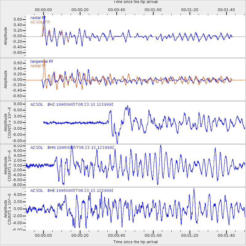
Signal To Noise
| Channel | StoN | STA | LTA |
| AZ:SOL: :BHN:19960905T08:23:13.123999Z | 1.1019349 | 5.411585E-7 | 4.910984E-7 |
| AZ:SOL: :BHE:19960905T08:23:13.123999Z | 1.2864554 | 6.4270904E-7 | 4.9959687E-7 |
| AZ:SOL: :BHZ:19960905T08:23:13.123999Z | 1.2119863 | 2.8106916E-7 | 2.3190788E-7 |
| Arrivals |
| Ps | 6.0 SECOND |
| PpPs | 20 SECOND |
| PsPs/PpSs | 26 SECOND |


