You are here: Home > Network List > XM99 - Rio Grande Seismic Transect Stations List
> Station UT53 Utah53 > Earthquake Result Viewer
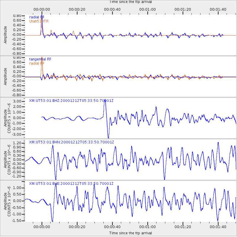
UT53 Utah53 - Earthquake Result Viewer

| Earthquake location: |
South Of Panama |
| Earthquake latitude/longitude: |
6.0/-82.7 |
| Earthquake time(UTC): |
2000/12/12 (347) 05:26:45 GMT |
| Earthquake Depth: |
10 km |
| Earthquake Magnitude: |
5.8 MB, 5.7 MS, 6.3 ME, 6.1 MW |
| Earthquake Catalog/Contributor: |
WHDF/NEIC |
|
| Network: |
XM Rio Grande Seismic Transect |
| Station: |
UT53 Utah53 |
| Lat/Lon: |
37.35 N/110.33 W |
| Elevation: |
1291 m |
|
| Distance: |
40.1 deg |
| Az: |
324.952 deg |
| Baz: |
134.221 deg |
| Ray Param: |
0.07459065 |
| Estimated Moho Depth: |
52.75 km |
| Estimated Crust Vp/Vs: |
1.75 |
| Assumed Crust Vp: |
6.247 km/s |
| Estimated Crust Vs: |
3.559 km/s |
| Estimated Crust Poisson's Ratio: |
0.26 |
|
| Radial Match: |
84.96224 % |
| Radial Bump: |
231 |
| Transverse Match: |
67.97893 % |
| Transverse Bump: |
400 |
| SOD ConfigId: |
27569 |
| Insert Time: |
2010-02-26 17:28:55.972 +0000 |
| GWidth: |
2.5 |
| Max Bumps: |
400 |
| Tol: |
0.001 |
|
Signal To Noise
| Channel | StoN | STA | LTA |
| XM:UT53:01:BHN:20001212T05:33:50.70001Z | 1.2474314 | 1.6031414E-7 | 1.285154E-7 |
| XM:UT53:01:BHE:20001212T05:33:50.70001Z | 1.1554794 | 1.7898967E-7 | 1.5490511E-7 |
| XM:UT53:01:BHZ:20001212T05:33:50.70001Z | 0.5952164 | 1.251709E-7 | 2.1029479E-7 |
| Arrivals |
| Ps | 6.8 SECOND |
| PpPs | 22 SECOND |
| PsPs/PpSs | 29 SECOND |


