You are here: Home > Network List > GS - US Geological Survey Networks Stations List
> Station ASL9 Albuquerque, New Mexico, USA > Earthquake Result Viewer
ASL9 Albuquerque, New Mexico, USA - Earthquake Result Viewer
| Earthquake location: |
Northern Alaska |
| Earthquake latitude/longitude: |
69.5/-144.4 |
| Earthquake time(UTC): |
2018/08/12 (224) 21:15:01 GMT |
| Earthquake Depth: |
1.7 km |
| Earthquake Magnitude: |
6.0 Mww |
| Earthquake Catalog/Contributor: |
NEIC PDE/ak |
|
| Network: |
GS US Geological Survey Networks |
| Station: |
ASL9 Albuquerque, New Mexico, USA |
| Lat/Lon: |
34.95 N/106.46 W |
| Elevation: |
1820 m |
|
| Distance: |
40.4 deg |
| Az: |
128.82 deg |
| Baz: |
340.501 deg |
| Ray Param: |
0.07445775 |
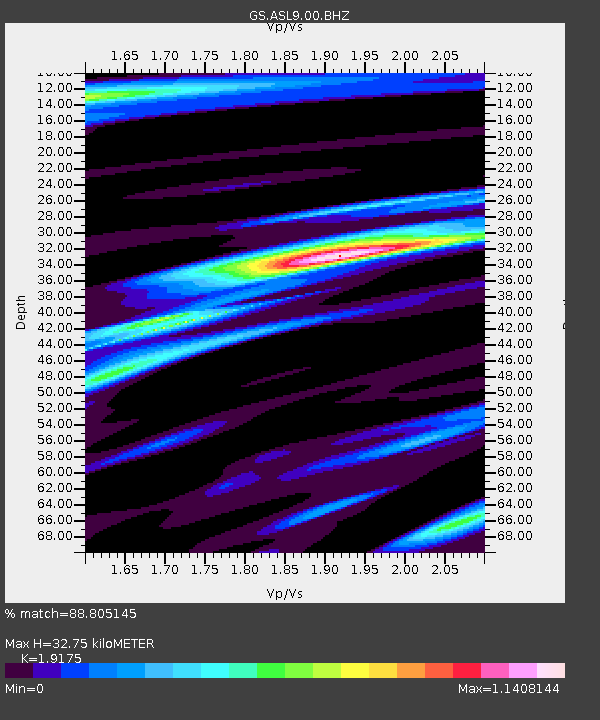
| Estimated Moho Depth: |
32.75 km |
| Estimated Crust Vp/Vs: |
1.92 |
| Assumed Crust Vp: |
6.502 km/s |
| Estimated Crust Vs: |
3.391 km/s |
| Estimated Crust Poisson's Ratio: |
0.31 |
|
| Radial Match: |
88.805145 % |
| Radial Bump: |
320 |
| Transverse Match: |
70.662926 % |
| Transverse Bump: |
400 |
| SOD ConfigId: |
2825771 |
| Insert Time: |
2018-08-26 21:23:42.176 +0000 |
| GWidth: |
2.5 |
| Max Bumps: |
400 |
| Tol: |
0.001 |
|

Signal To Noise
| Channel | StoN | STA | LTA |
| GS:ASL9:00:BHZ:20180812T21:22:10.169003Z | 8.014711 | 4.1468942E-7 | 5.174103E-8 |
| GS:ASL9:00:BH1:20180812T21:22:10.169003Z | 4.072286 | 2.446152E-7 | 6.0068274E-8 |
| GS:ASL9:00:BH2:20180812T21:22:10.169003Z | 3.2874846 | 1.5069169E-7 | 4.583799E-8 |
| Arrivals |
| Ps | 4.9 SECOND |
| PpPs | 14 SECOND |
| PsPs/PpSs | 19 SECOND |


