You are here: Home > Network List > AZ - ANZA Regional Network Stations List
> Station TRO AZ.TRO > Earthquake Result Viewer
TRO AZ.TRO - Earthquake Result Viewer
| Earthquake location: |
Near Coast Of Guatemala |
| Earthquake latitude/longitude: |
13.8/-90.8 |
| Earthquake time(UTC): |
2007/06/08 (159) 13:32:00 GMT |
| Earthquake Depth: |
48 km |
| Earthquake Magnitude: |
5.5 MB, 5.4 MS, 5.8 MW, 5.8 MW |
| Earthquake Catalog/Contributor: |
WHDF/NEIC |
|
| Network: |
AZ ANZA Regional Network |
| Station: |
TRO AZ.TRO |
| Lat/Lon: |
33.52 N/116.43 W |
| Elevation: |
2628 m |
|
| Distance: |
30.5 deg |
| Az: |
314.465 deg |
| Baz: |
123.915 deg |
| Ray Param: |
0.079268456 |
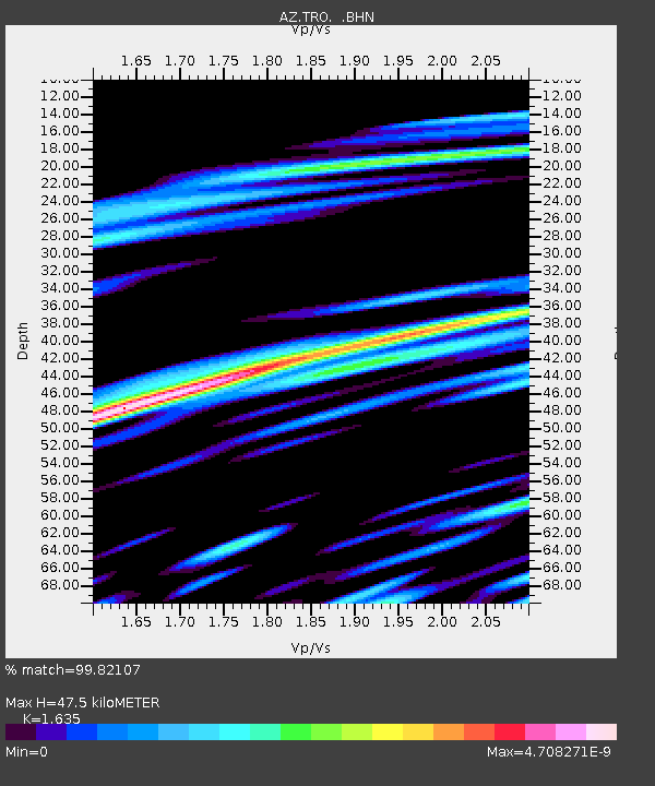
| Estimated Moho Depth: |
47.5 km |
| Estimated Crust Vp/Vs: |
1.63 |
| Assumed Crust Vp: |
6.264 km/s |
| Estimated Crust Vs: |
3.831 km/s |
| Estimated Crust Poisson's Ratio: |
0.20 |
|
| Radial Match: |
99.82107 % |
| Radial Bump: |
20 |
| Transverse Match: |
99.76571 % |
| Transverse Bump: |
25 |
| SOD ConfigId: |
2564 |
| Insert Time: |
2010-03-09 21:06:44.740 +0000 |
| GWidth: |
2.5 |
| Max Bumps: |
400 |
| Tol: |
0.001 |
|

Signal To Noise
| Channel | StoN | STA | LTA |
| AZ:TRO: :BHN:20070608T13:37:38.698009Z | 1.2745703 | 2.2213005E-7 | 1.7427837E-7 |
| AZ:TRO: :BHE:20070608T13:37:38.698009Z | 1.0215291 | 6.6872764E-7 | 6.54634E-7 |
| AZ:TRO: :BHZ:20070608T13:37:38.698009Z | 0.77503455 | 6.0051696E-7 | 7.7482605E-7 |
| Arrivals |
| Ps | 5.2 SECOND |
| PpPs | 18 SECOND |
| PsPs/PpSs | 24 SECOND |


