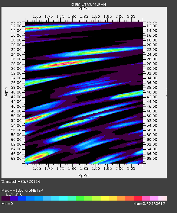
UT53 Utah53 - Earthquake Result Viewer
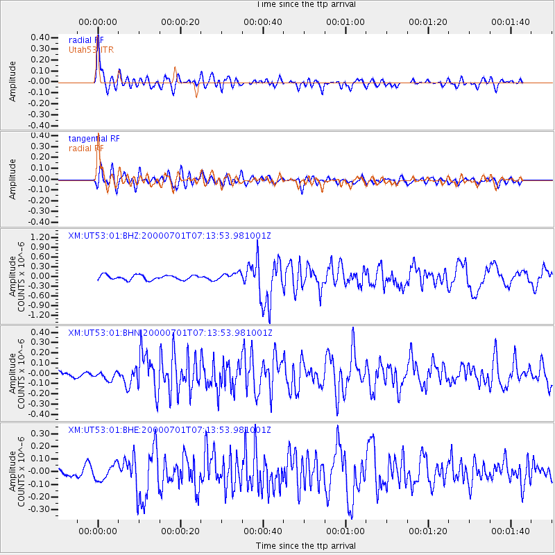
Earthquake location: Near S. Coast Of Honshu, Japan
Earthquake latitude/longitude: 34.2/139.1
Earthquake time(UTC): 2000/07/01 (183) 07:01:55 GMT
Earthquake Depth: 10 km
Earthquake Magnitude: 6.0 MB, 6.1 MS, 6.2 MW, 6.2 MW
Earthquake Catalog/Contributor: WHDF/NEIC
Network: XM Rio Grande Seismic Transect
Station: UT53 Utah53
Lat/Lon: 37.35 N/110.33 W
Elevation: 1291 m
Distance: 83.9 deg
Az: 48.639 deg
Baz: 308.703 deg
Ray Param: 0.045867614
Estimated Moho Depth: 13.0 km
Estimated Crust Vp/Vs: 1.62
Assumed Crust Vp: 6.247 km/s
Estimated Crust Vs: 3.868 km/s
Estimated Crust Poisson's Ratio: 0.19
Radial Match: 85.720116 %
Radial Bump: 400
Transverse Match: 75.05273 %
Transverse Bump: 400
SOD ConfigId: 27569
Insert Time: 2010-02-26 17:29:01.744 +0000
GWidth: 2.5
Max Bumps: 400
Tol: 0.001

Signal To Noise

ChannelStoNSTALTA
XM:UT53:01:BHN:20000701T07:13:53.981001Z1.31733474.3057256E-83.268513E-8
XM:UT53:01:BHE:20000701T07:13:53.981001Z1.64494696.322563E-83.8436273E-8
XM:UT53:01:BHZ:20000701T07:13:53.981001Z1.57486831.13466356E-77.204815E-8
Arrivals
Ps1.3 SECOND
PpPs5.3 SECOND
PsPs/PpSs6.6 SECOND