You are here: Home > Network List > XM99 - Rio Grande Seismic Transect Stations List
> Station UT53 Utah53 > Earthquake Result Viewer
UT53 Utah53 - Earthquake Result Viewer

| Earthquake location: |
Southern Greece |
| Earthquake latitude/longitude: |
36.0/22.0 |
| Earthquake time(UTC): |
2000/05/24 (145) 05:40:37 GMT |
| Earthquake Depth: |
33 km |
| Earthquake Magnitude: |
5.3 MB, 5.6 MS, 5.9 MW, 5.7 MW |
| Earthquake Catalog/Contributor: |
WHDF/NEIC |
|
| Network: |
XM Rio Grande Seismic Transect |
| Station: |
UT53 Utah53 |
| Lat/Lon: |
37.35 N/110.33 W |
| Elevation: |
1291 m |
|
| Distance: |
94.7 deg |
| Az: |
323.772 deg |
| Baz: |
36.943 deg |
| Ray Param: |
0.04097499 |
| Estimated Moho Depth: |
29.0 km |
| Estimated Crust Vp/Vs: |
1.60 |
| Assumed Crust Vp: |
6.247 km/s |
| Estimated Crust Vs: |
3.904 km/s |
| Estimated Crust Poisson's Ratio: |
0.18 |
|
| Radial Match: |
81.44297 % |
| Radial Bump: |
400 |
| Transverse Match: |
61.414818 % |
| Transverse Bump: |
400 |
| SOD ConfigId: |
27569 |
| Insert Time: |
2010-02-26 17:29:04.413 +0000 |
| GWidth: |
2.5 |
| Max Bumps: |
400 |
| Tol: |
0.001 |
|
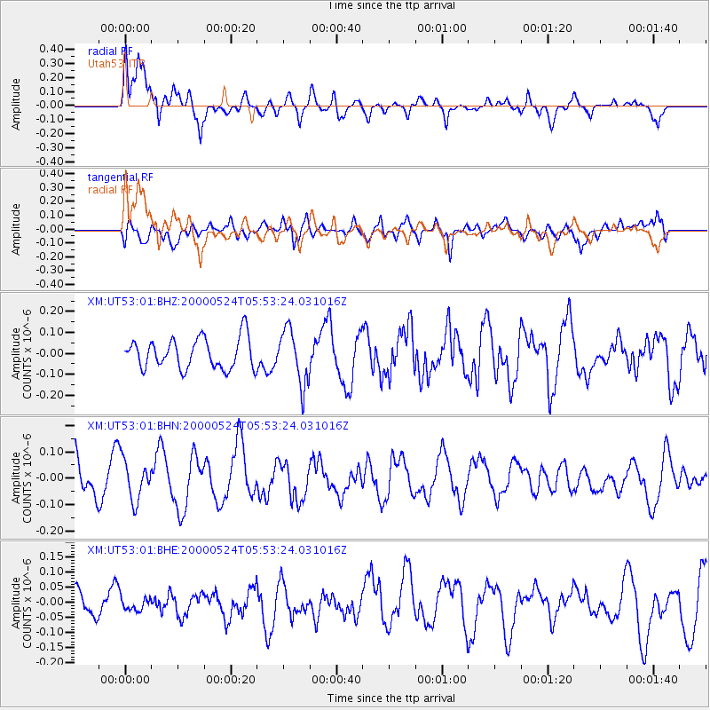
Signal To Noise
| Channel | StoN | STA | LTA |
| XM:UT53:01:BHN:20000524T05:53:24.031016Z | 0.92870104 | 7.3789984E-8 | 7.945505E-8 |
| XM:UT53:01:BHE:20000524T05:53:24.031016Z | 0.41587913 | 1.960406E-8 | 4.713884E-8 |
| XM:UT53:01:BHZ:20000524T05:53:24.031016Z | 1.8109052 | 1.3119913E-7 | 7.2449474E-8 |
| Arrivals |
| Ps | 2.8 SECOND |
| PpPs | 12 SECOND |
| PsPs/PpSs | 15 SECOND |


