You are here: Home > Network List > XM99 - Rio Grande Seismic Transect Stations List
> Station UT53 Utah53 > Earthquake Result Viewer
UT53 Utah53 - Earthquake Result Viewer

| Earthquake location: |
Vanuatu Islands |
| Earthquake latitude/longitude: |
-15.4/166.9 |
| Earthquake time(UTC): |
2000/10/04 (278) 16:58:44 GMT |
| Earthquake Depth: |
23 km |
| Earthquake Magnitude: |
6.1 MB, 6.9 MS, 6.8 MW, 6.5 ME |
| Earthquake Catalog/Contributor: |
WHDF/NEIC |
|
| Network: |
XM Rio Grande Seismic Transect |
| Station: |
UT53 Utah53 |
| Lat/Lon: |
37.35 N/110.33 W |
| Elevation: |
1291 m |
|
| Distance: |
93.6 deg |
| Az: |
52.387 deg |
| Baz: |
253.466 deg |
| Ray Param: |
0.04122334 |
| Estimated Moho Depth: |
18.5 km |
| Estimated Crust Vp/Vs: |
1.84 |
| Assumed Crust Vp: |
6.247 km/s |
| Estimated Crust Vs: |
3.399 km/s |
| Estimated Crust Poisson's Ratio: |
0.29 |
|
| Radial Match: |
90.552795 % |
| Radial Bump: |
400 |
| Transverse Match: |
77.26019 % |
| Transverse Bump: |
400 |
| SOD ConfigId: |
16820 |
| Insert Time: |
2010-02-26 17:29:08.810 +0000 |
| GWidth: |
2.5 |
| Max Bumps: |
400 |
| Tol: |
0.001 |
|
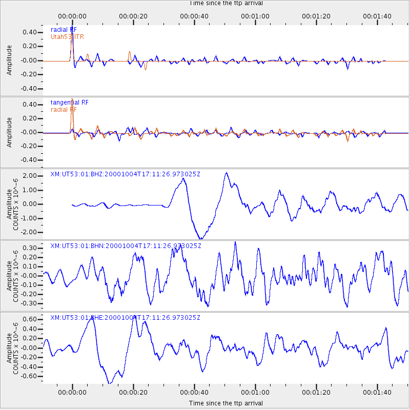
Signal To Noise
| Channel | StoN | STA | LTA |
| XM:UT53:01:BHN:20001004T17:11:26.973025Z | 1.0116261 | 6.582532E-8 | 6.5068825E-8 |
| XM:UT53:01:BHE:20001004T17:11:26.973025Z | 2.8132284 | 2.2338418E-7 | 7.940492E-8 |
| XM:UT53:01:BHZ:20001004T17:11:26.973025Z | 8.244801 | 6.428698E-7 | 7.797276E-8 |
| Arrivals |
| Ps | 2.5 SECOND |
| PpPs | 8.3 SECOND |
| PsPs/PpSs | 11 SECOND |


