You are here: Home > Network List > AZ - ANZA Regional Network Stations List
> Station TRO AZ.TRO > Earthquake Result Viewer
TRO AZ.TRO - Earthquake Result Viewer
| Earthquake location: |
Guatemala |
| Earthquake latitude/longitude: |
14.0/-91.1 |
| Earthquake time(UTC): |
2003/08/25 (237) 06:28:35 GMT |
| Earthquake Depth: |
100 km |
| Earthquake Magnitude: |
5.4 MB, 5.9 MW, 5.9 MW |
| Earthquake Catalog/Contributor: |
WHDF/NEIC |
|
| Network: |
AZ ANZA Regional Network |
| Station: |
TRO AZ.TRO |
| Lat/Lon: |
33.52 N/116.43 W |
| Elevation: |
2628 m |
|
| Distance: |
30.1 deg |
| Az: |
314.504 deg |
| Baz: |
124.044 deg |
| Ray Param: |
0.07925469 |
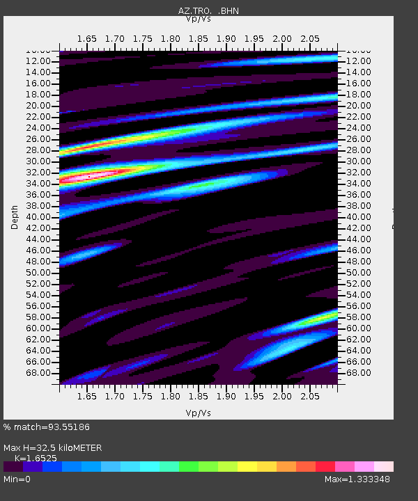
| Estimated Moho Depth: |
32.5 km |
| Estimated Crust Vp/Vs: |
1.65 |
| Assumed Crust Vp: |
6.264 km/s |
| Estimated Crust Vs: |
3.79 km/s |
| Estimated Crust Poisson's Ratio: |
0.21 |
|
| Radial Match: |
93.55186 % |
| Radial Bump: |
389 |
| Transverse Match: |
82.46241 % |
| Transverse Bump: |
400 |
| SOD ConfigId: |
32974 |
| Insert Time: |
2010-03-09 21:08:52.720 +0000 |
| GWidth: |
2.5 |
| Max Bumps: |
400 |
| Tol: |
0.001 |
|

Signal To Noise
| Channel | StoN | STA | LTA |
| AZ:TRO: :BHN:20030825T06:34:05.125007Z | 3.658215 | 5.881324E-7 | 1.6077033E-7 |
| AZ:TRO: :BHE:20030825T06:34:05.125007Z | 5.467822 | 6.557604E-7 | 1.1993083E-7 |
| AZ:TRO: :BHZ:20030825T06:34:05.125007Z | 7.003065 | 1.1759836E-6 | 1.6792413E-7 |
| Arrivals |
| Ps | 3.7 SECOND |
| PpPs | 13 SECOND |
| PsPs/PpSs | 16 SECOND |


