You are here: Home > Network List > AZ - ANZA Regional Network Stations List
> Station TRO AZ.TRO > Earthquake Result Viewer
TRO AZ.TRO - Earthquake Result Viewer
| Earthquake location: |
Near East Coast Of Honshu, Japan |
| Earthquake latitude/longitude: |
38.8/141.6 |
| Earthquake time(UTC): |
2003/05/26 (146) 09:24:33 GMT |
| Earthquake Depth: |
68 km |
| Earthquake Magnitude: |
6.7 MB, 7.0 MW, 7.0 MW |
| Earthquake Catalog/Contributor: |
WHDF/NEIC |
|
| Network: |
AZ ANZA Regional Network |
| Station: |
TRO AZ.TRO |
| Lat/Lon: |
33.52 N/116.43 W |
| Elevation: |
2628 m |
|
| Distance: |
78.0 deg |
| Az: |
56.648 deg |
| Baz: |
308.666 deg |
| Ray Param: |
0.04979178 |
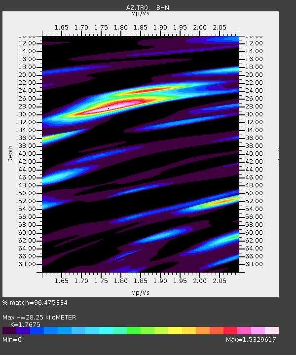
| Estimated Moho Depth: |
28.25 km |
| Estimated Crust Vp/Vs: |
1.77 |
| Assumed Crust Vp: |
6.264 km/s |
| Estimated Crust Vs: |
3.544 km/s |
| Estimated Crust Poisson's Ratio: |
0.26 |
|
| Radial Match: |
96.475334 % |
| Radial Bump: |
400 |
| Transverse Match: |
90.48533 % |
| Transverse Bump: |
400 |
| SOD ConfigId: |
32974 |
| Insert Time: |
2010-03-09 21:09:06.118 +0000 |
| GWidth: |
2.5 |
| Max Bumps: |
400 |
| Tol: |
0.001 |
|

Signal To Noise
| Channel | StoN | STA | LTA |
| AZ:TRO: :BHN:20030526T09:35:53.498999Z | 3.8455927 | 1.051434E-6 | 2.7341272E-7 |
| AZ:TRO: :BHE:20030526T09:35:53.498999Z | 3.6718621 | 1.0165736E-6 | 2.7685505E-7 |
| AZ:TRO: :BHZ:20030526T09:35:53.498999Z | 20.206003 | 3.7682387E-6 | 1.8649105E-7 |
| Arrivals |
| Ps | 3.6 SECOND |
| PpPs | 12 SECOND |
| PsPs/PpSs | 16 SECOND |


