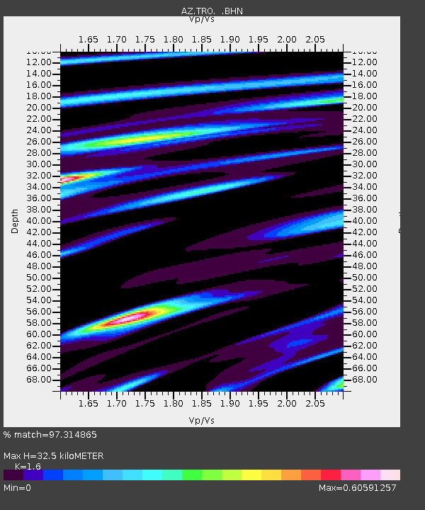
TRO AZ.TRO - Earthquake Result Viewer

Earthquake location: Near West Coast Of Colombia
Earthquake latitude/longitude: 4.7/-77.5
Earthquake time(UTC): 2004/11/15 (320) 09:06:56 GMT
Earthquake Depth: 15 km
Earthquake Magnitude: 6.6 MB, 7.1 MS, 7.2 MW, 7.1 MW
Earthquake Catalog/Contributor: WHDF/NEIC
Network: AZ ANZA Regional Network
Station: TRO AZ.TRO
Lat/Lon: 33.52 N/116.43 W
Elevation: 2628 m
Distance: 46.2 deg
Az: 313.329 deg
Baz: 119.784 deg
Ray Param: 0.070796445
Estimated Moho Depth: 32.5 km
Estimated Crust Vp/Vs: 1.60
Assumed Crust Vp: 6.264 km/s
Estimated Crust Vs: 3.915 km/s
Estimated Crust Poisson's Ratio: 0.18
Radial Match: 97.314865 %
Radial Bump: 400
Transverse Match: 85.998474 %
Transverse Bump: 400
SOD ConfigId: 2459
Insert Time: 2010-03-09 21:09:22.950 +0000
GWidth: 2.5
Max Bumps: 400
Tol: 0.001

Signal To Noise

ChannelStoNSTALTA
AZ:TRO: :BHN:20041115T09:14:49.600009Z5.4940611.8056493E-63.2865475E-7
AZ:TRO: :BHE:20041115T09:14:49.600009Z9.4911593.2959783E-63.4726824E-7
AZ:TRO: :BHZ:20041115T09:14:49.600009Z28.7025935.5263163E-61.9253717E-7
Arrivals
Ps3.3 SECOND
PpPs13 SECOND
PsPs/PpSs16 SECOND