You are here: Home > Network List > XM99 - Rio Grande Seismic Transect Stations List
> Station UT53 Utah53 > Earthquake Result Viewer
UT53 Utah53 - Earthquake Result Viewer

| Earthquake location: |
Tonga Islands |
| Earthquake latitude/longitude: |
-17.2/-173.9 |
| Earthquake time(UTC): |
2000/09/26 (270) 06:17:52 GMT |
| Earthquake Depth: |
56 km |
| Earthquake Magnitude: |
6.1 MB, 6.1 MS, 6.4 MW, 6.1 ME |
| Earthquake Catalog/Contributor: |
WHDF/NEIC |
|
| Network: |
XM Rio Grande Seismic Transect |
| Station: |
UT53 Utah53 |
| Lat/Lon: |
37.35 N/110.33 W |
| Elevation: |
1291 m |
|
| Distance: |
80.7 deg |
| Az: |
46.328 deg |
| Baz: |
240.182 deg |
| Ray Param: |
0.04799166 |
| Estimated Moho Depth: |
39.75 km |
| Estimated Crust Vp/Vs: |
1.79 |
| Assumed Crust Vp: |
6.247 km/s |
| Estimated Crust Vs: |
3.495 km/s |
| Estimated Crust Poisson's Ratio: |
0.27 |
|
| Radial Match: |
96.50801 % |
| Radial Bump: |
400 |
| Transverse Match: |
88.26335 % |
| Transverse Bump: |
400 |
| SOD ConfigId: |
16820 |
| Insert Time: |
2010-02-26 17:29:11.047 +0000 |
| GWidth: |
2.5 |
| Max Bumps: |
400 |
| Tol: |
0.001 |
|
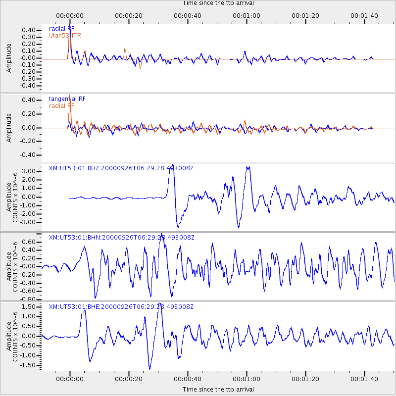
Signal To Noise
| Channel | StoN | STA | LTA |
| XM:UT53:01:BHN:20000926T06:29:28.493008Z | 2.8209922 | 2.0052937E-7 | 7.108469E-8 |
| XM:UT53:01:BHE:20000926T06:29:28.493008Z | 11.86493 | 5.518911E-7 | 4.6514483E-8 |
| XM:UT53:01:BHZ:20000926T06:29:28.493008Z | 24.052797 | 1.635372E-6 | 6.799093E-8 |
| Arrivals |
| Ps | 5.1 SECOND |
| PpPs | 17 SECOND |
| PsPs/PpSs | 22 SECOND |


