You are here: Home > Network List > XM99 - Rio Grande Seismic Transect Stations List
> Station UT53 Utah53 > Earthquake Result Viewer
UT53 Utah53 - Earthquake Result Viewer
| Earthquake location: |
Fiji Islands |
| Earthquake latitude/longitude: |
-15.7/179.8 |
| Earthquake time(UTC): |
2000/09/14 (258) 14:59:57 GMT |
| Earthquake Depth: |
33 km |
| Earthquake Magnitude: |
5.7 MB, 6.2 MS, 6.3 MW, 6.2 MW |
| Earthquake Catalog/Contributor: |
WHDF/NEIC |
|
| Network: |
XM Rio Grande Seismic Transect |
| Station: |
UT53 Utah53 |
| Lat/Lon: |
37.35 N/110.33 W |
| Elevation: |
1291 m |
|
| Distance: |
84.2 deg |
| Az: |
48.775 deg |
| Baz: |
245.34 deg |
| Ray Param: |
0.045617137 |
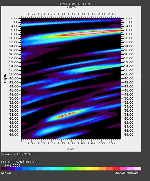
| Estimated Moho Depth: |
17.25 km |
| Estimated Crust Vp/Vs: |
1.92 |
| Assumed Crust Vp: |
6.247 km/s |
| Estimated Crust Vs: |
3.249 km/s |
| Estimated Crust Poisson's Ratio: |
0.31 |
|
| Radial Match: |
83.62326 % |
| Radial Bump: |
400 |
| Transverse Match: |
71.86679 % |
| Transverse Bump: |
400 |
| SOD ConfigId: |
16820 |
| Insert Time: |
2010-02-26 17:29:11.928 +0000 |
| GWidth: |
2.5 |
| Max Bumps: |
400 |
| Tol: |
0.001 |
|

Signal To Noise
| Channel | StoN | STA | LTA |
| XM:UT53:01:BHN:20000914T15:11:54.469011Z | 1.7340207 | 9.748965E-8 | 5.622173E-8 |
| XM:UT53:01:BHE:20000914T15:11:54.469011Z | 1.7529551 | 9.155432E-8 | 5.2228557E-8 |
| XM:UT53:01:BHZ:20000914T15:11:54.469011Z | 2.821487 | 2.5275602E-7 | 8.958257E-8 |
| Arrivals |
| Ps | 2.6 SECOND |
| PpPs | 7.9 SECOND |
| PsPs/PpSs | 11 SECOND |


