You are here: Home > Network List > UW - Pacific Northwest Regional Seismic Network Stations List
> Station HOOD Mt Hood Meadows, OR CREST BB SMO > Earthquake Result Viewer
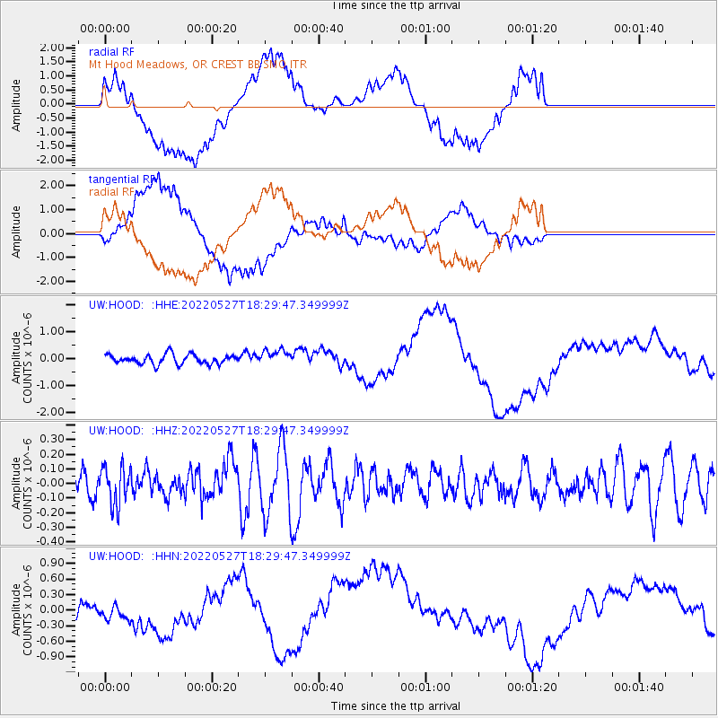
HOOD Mt Hood Meadows, OR CREST BB SMO - Earthquake Result Viewer
*The percent match for this event was below the threshold and hence no stack was calculated.
| Earthquake location: |
Northern East Pacific Rise |
| Earthquake latitude/longitude: |
8.4/-103.0 |
| Earthquake time(UTC): |
2022/05/27 (147) 18:22:42 GMT |
| Earthquake Depth: |
10 km |
| Earthquake Magnitude: |
5.4 Mww |
| Earthquake Catalog/Contributor: |
NEIC PDE/us |
|
| Network: |
UW Pacific Northwest Regional Seismic Network |
| Station: |
HOOD Mt Hood Meadows, OR CREST BB SMO |
| Lat/Lon: |
45.32 N/121.65 W |
| Elevation: |
1520 m |
|
| Distance: |
40.1 deg |
| Az: |
339.492 deg |
| Baz: |
150.576 deg |
| Ray Param: |
$rayparam |
*The percent match for this event was below the threshold and hence was not used in the summary stack. |
|
| Radial Match: |
50.19406 % |
| Radial Bump: |
400 |
| Transverse Match: |
51.775806 % |
| Transverse Bump: |
400 |
| SOD ConfigId: |
28208852 |
| Insert Time: |
2022-06-27 19:46:07.257 +0000 |
| GWidth: |
2.5 |
| Max Bumps: |
400 |
| Tol: |
0.001 |
|
Signal To Noise
| Channel | StoN | STA | LTA |
| UW:HOOD: :HHZ:20220527T18:29:47.349999Z | 1.3766034 | 1.3055082E-7 | 9.483546E-8 |
| UW:HOOD: :HHN:20220527T18:29:47.349999Z | 0.59829706 | 1.84118E-7 | 3.0773674E-7 |
| UW:HOOD: :HHE:20220527T18:29:47.349999Z | 1.5938267 | 2.8669976E-7 | 1.798814E-7 |
| Arrivals |
| Ps | |
| PpPs | |
| PsPs/PpSs | |


