You are here: Home > Network List > AZ - ANZA Regional Network Stations List
> Station TRO AZ.TRO > Earthquake Result Viewer
TRO AZ.TRO - Earthquake Result Viewer
| Earthquake location: |
Northern Peru |
| Earthquake latitude/longitude: |
-5.7/-76.4 |
| Earthquake time(UTC): |
2005/09/26 (269) 01:55:37 GMT |
| Earthquake Depth: |
115 km |
| Earthquake Magnitude: |
6.7 MB, 7.5 MW, 7.5 MW |
| Earthquake Catalog/Contributor: |
WHDF/NEIC |
|
| Network: |
AZ ANZA Regional Network |
| Station: |
TRO AZ.TRO |
| Lat/Lon: |
33.52 N/116.43 W |
| Elevation: |
2628 m |
|
| Distance: |
54.4 deg |
| Az: |
318.623 deg |
| Baz: |
128.052 deg |
| Ray Param: |
0.06513333 |
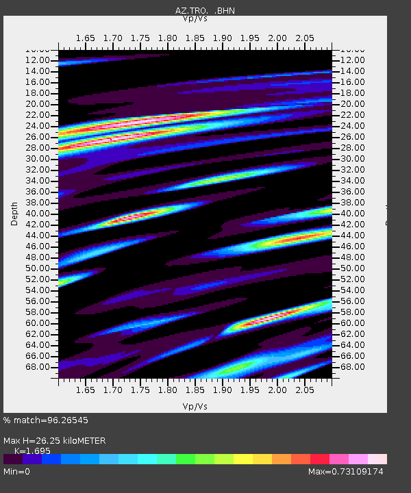
| Estimated Moho Depth: |
26.25 km |
| Estimated Crust Vp/Vs: |
1.70 |
| Assumed Crust Vp: |
6.264 km/s |
| Estimated Crust Vs: |
3.695 km/s |
| Estimated Crust Poisson's Ratio: |
0.23 |
|
| Radial Match: |
96.26545 % |
| Radial Bump: |
400 |
| Transverse Match: |
81.66807 % |
| Transverse Bump: |
400 |
| SOD ConfigId: |
2475 |
| Insert Time: |
2010-03-09 21:10:08.918 +0000 |
| GWidth: |
2.5 |
| Max Bumps: |
400 |
| Tol: |
0.001 |
|

Signal To Noise
| Channel | StoN | STA | LTA |
| AZ:TRO: :BHN:20050926T02:04:21.974016Z | 17.805376 | 5.065704E-6 | 2.8450418E-7 |
| AZ:TRO: :BHE:20050926T02:04:21.974016Z | 37.353924 | 7.0253136E-6 | 1.8807431E-7 |
| AZ:TRO: :BHZ:20050926T02:04:21.974016Z | 44.62231 | 1.4524208E-5 | 3.2549207E-7 |
| Arrivals |
| Ps | 3.1 SECOND |
| PpPs | 11 SECOND |
| PsPs/PpSs | 14 SECOND |


