You are here: Home > Network List > XM99 - Rio Grande Seismic Transect Stations List
> Station UT53 Utah53 > Earthquake Result Viewer
UT53 Utah53 - Earthquake Result Viewer
| Earthquake location: |
El Salvador |
| Earthquake latitude/longitude: |
13.0/-88.7 |
| Earthquake time(UTC): |
2001/01/13 (013) 17:33:32 GMT |
| Earthquake Depth: |
60 km |
| Earthquake Magnitude: |
6.4 MB, 7.8 MS, 7.7 MW, 7.5 ME |
| Earthquake Catalog/Contributor: |
WHDF/NEIC |
|
| Network: |
XM Rio Grande Seismic Transect |
| Station: |
UT53 Utah53 |
| Lat/Lon: |
37.35 N/110.33 W |
| Elevation: |
1291 m |
|
| Distance: |
31.0 deg |
| Az: |
325.14 deg |
| Baz: |
135.66 deg |
| Ray Param: |
0.079103634 |
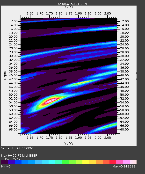
| Estimated Moho Depth: |
52.75 km |
| Estimated Crust Vp/Vs: |
1.76 |
| Assumed Crust Vp: |
6.247 km/s |
| Estimated Crust Vs: |
3.554 km/s |
| Estimated Crust Poisson's Ratio: |
0.26 |
|
| Radial Match: |
97.037926 % |
| Radial Bump: |
232 |
| Transverse Match: |
81.709984 % |
| Transverse Bump: |
400 |
| SOD ConfigId: |
16820 |
| Insert Time: |
2010-02-26 17:29:12.869 +0000 |
| GWidth: |
2.5 |
| Max Bumps: |
400 |
| Tol: |
0.001 |
|
Signal To Noise
| Channel | StoN | STA | LTA |
| XM:UT53:01:BHN:20010113T17:39:13.877009Z | 2.5444448 | 8.6174214E-7 | 3.386759E-7 |
| XM:UT53:01:BHE:20010113T17:39:13.877009Z | 2.6699808 | 1.0678328E-6 | 3.999403E-7 |
| XM:UT53:01:BHZ:20010113T17:39:13.877009Z | 6.408867 | 2.117865E-6 | 3.304586E-7 |
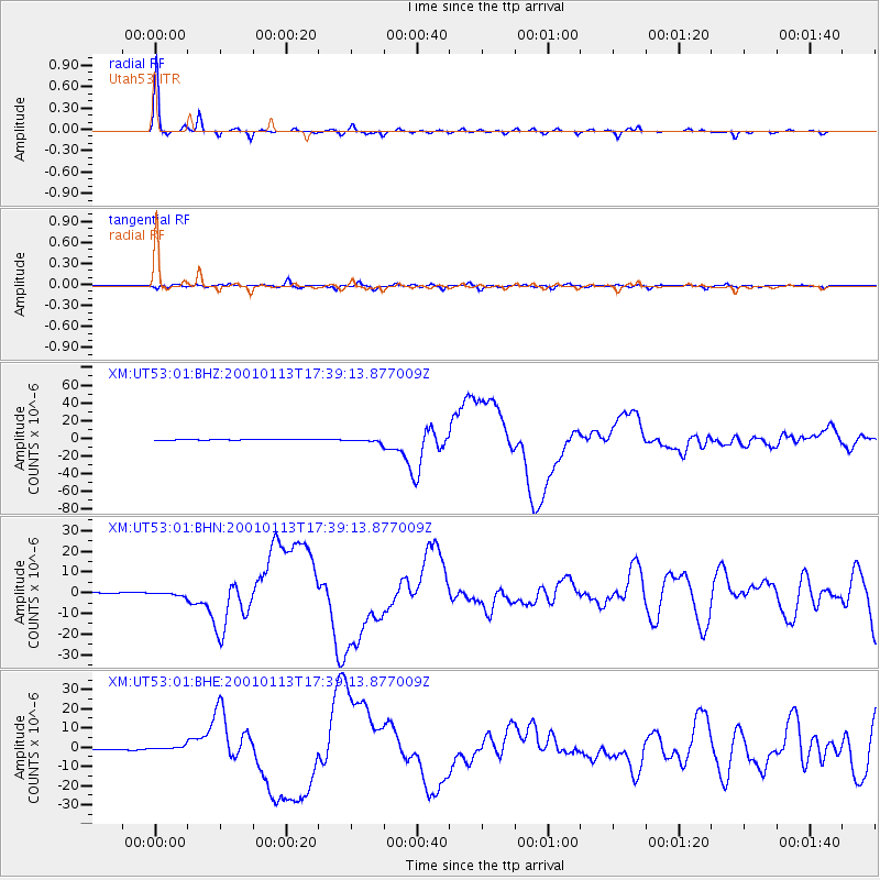
| Arrivals |
| Ps | 6.9 SECOND |
| PpPs | 22 SECOND |
| PsPs/PpSs | 28 SECOND |


