You are here: Home > Network List > NM - Cooperative New Madrid Seismic Network Stations List
> Station PARM Stahl Farm,MO > Earthquake Result Viewer
PARM Stahl Farm,MO - Earthquake Result Viewer
| Earthquake location: |
Northern Alaska |
| Earthquake latitude/longitude: |
69.5/-144.4 |
| Earthquake time(UTC): |
2018/08/12 (224) 21:15:01 GMT |
| Earthquake Depth: |
1.7 km |
| Earthquake Magnitude: |
6.0 Mww |
| Earthquake Catalog/Contributor: |
NEIC PDE/ak |
|
| Network: |
NM Cooperative New Madrid Seismic Network |
| Station: |
PARM Stahl Farm,MO |
| Lat/Lon: |
36.66 N/89.75 W |
| Elevation: |
85 m |
|
| Distance: |
43.9 deg |
| Az: |
109.074 deg |
| Baz: |
335.565 deg |
| Ray Param: |
0.07226566 |
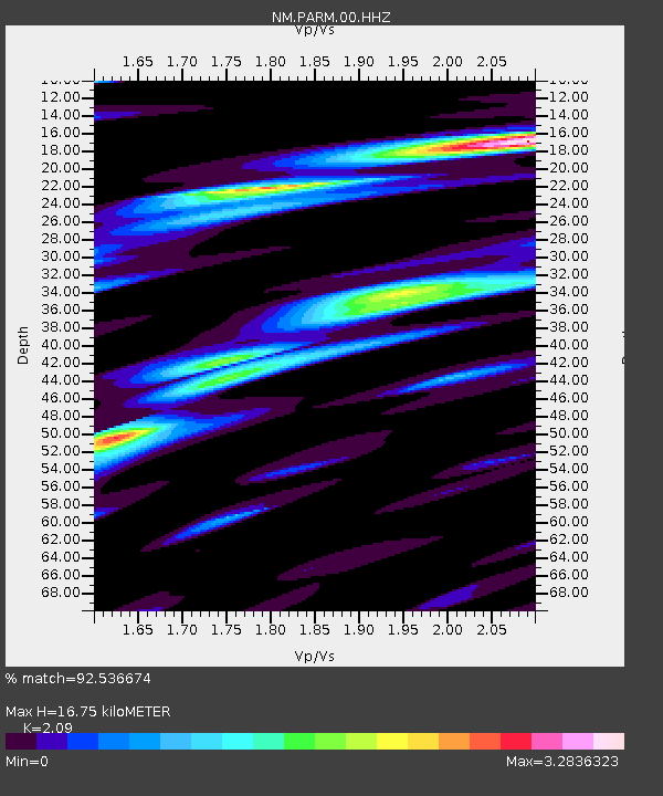
| Estimated Moho Depth: |
16.75 km |
| Estimated Crust Vp/Vs: |
2.09 |
| Assumed Crust Vp: |
6.444 km/s |
| Estimated Crust Vs: |
3.083 km/s |
| Estimated Crust Poisson's Ratio: |
0.35 |
|
| Radial Match: |
92.536674 % |
| Radial Bump: |
350 |
| Transverse Match: |
76.91665 % |
| Transverse Bump: |
400 |
| SOD ConfigId: |
2825771 |
| Insert Time: |
2018-08-26 21:26:52.751 +0000 |
| GWidth: |
2.5 |
| Max Bumps: |
400 |
| Tol: |
0.001 |
|

Signal To Noise
| Channel | StoN | STA | LTA |
| NM:PARM:00:HHZ:20180812T21:22:39.015011Z | 16.15601 | 1.8631367E-6 | 1.153216E-7 |
| NM:PARM:00:HHN:20180812T21:22:39.015011Z | 14.358977 | 2.7787084E-6 | 1.9351715E-7 |
| NM:PARM:00:HHE:20180812T21:22:39.015011Z | 5.5618296 | 1.2248706E-6 | 2.2022799E-7 |
| Arrivals |
| Ps | 3.0 SECOND |
| PpPs | 7.6 SECOND |
| PsPs/PpSs | 11 SECOND |


