You are here: Home > Network List > XM99 - Rio Grande Seismic Transect Stations List
> Station UT53 Utah53 > Earthquake Result Viewer
UT53 Utah53 - Earthquake Result Viewer

| Earthquake location: |
El Salvador |
| Earthquake latitude/longitude: |
13.7/-88.9 |
| Earthquake time(UTC): |
2001/02/13 (044) 14:22:05 GMT |
| Earthquake Depth: |
10 km |
| Earthquake Magnitude: |
5.5 MB, 6.5 MS, 6.6 MW, 6.1 MD |
| Earthquake Catalog/Contributor: |
WHDF/NEIC |
|
| Network: |
XM Rio Grande Seismic Transect |
| Station: |
UT53 Utah53 |
| Lat/Lon: |
37.35 N/110.33 W |
| Elevation: |
1291 m |
|
| Distance: |
30.3 deg |
| Az: |
324.852 deg |
| Baz: |
135.399 deg |
| Ray Param: |
0.07936087 |
| Estimated Moho Depth: |
28.0 km |
| Estimated Crust Vp/Vs: |
1.79 |
| Assumed Crust Vp: |
6.247 km/s |
| Estimated Crust Vs: |
3.495 km/s |
| Estimated Crust Poisson's Ratio: |
0.27 |
|
| Radial Match: |
88.72081 % |
| Radial Bump: |
320 |
| Transverse Match: |
59.61997 % |
| Transverse Bump: |
400 |
| SOD ConfigId: |
3744 |
| Insert Time: |
2010-02-26 17:29:16.732 +0000 |
| GWidth: |
2.5 |
| Max Bumps: |
400 |
| Tol: |
0.001 |
|
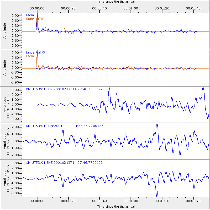
Signal To Noise
| Channel | StoN | STA | LTA |
| XM:UT53:01:BHN:20010213T14:27:46.770012Z | 1.121259 | 1.1173261E-7 | 9.964924E-8 |
| XM:UT53:01:BHE:20010213T14:27:46.770012Z | 0.7874201 | 1.2401259E-7 | 1.574923E-7 |
| XM:UT53:01:BHZ:20010213T14:27:46.770012Z | 0.99930245 | 1.781732E-7 | 1.7829757E-7 |
| Arrivals |
| Ps | 3.8 SECOND |
| PpPs | 12 SECOND |
| PsPs/PpSs | 15 SECOND |


